Jimboomba geodata
Jimboomba (Queensland) is a section of populated place; located in Australia in Australia/Brisbane (GMT+10) time zone. With population of 12,981 people, there are 359 cities with bigger population in this country. Compared to other cities in Australia, 77% of cities are located further ↓South; 92.2% of cities are located further ←West and 51.7% of cities have higher elevation than Jimboomba. Note1


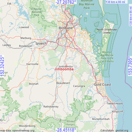
Jimboomba GPS coordinates[2]
27° 49' 52.248" South, 153° 1' 38.532" East
| Map corner | latitude | longitude |
|---|---|---|
| Upper-left | -27.20762°, | 152.32425° |
| Center: | -27.83118°, | 153.02737° |
| Lower-right: | -28.45118°, | 153.7305° |
| Map W x H: | 138.3×138.3 km | = 85.9×85.9mi |
| max Lat: | -10.58257° ⇑23% North |
| Jimboomba: | -27.83118° |
| min Lat: | ⇓77% South -43.31423° |
| min Long | Jimboomba | max Long |
| 113.53327° | 153.02737° | 153.61246° |
| W 92.2%⇐ | ⇒7.8% E |
Elevation
Elevation of Jimboomba is 43 m = 141 ft, and this is 79 m = 259 ft below average elevation for this country.
| Max E: |
1715 m = 5627 ft | 51.7% |
| Avg. | 122 m = 400 ft | |
| Jimboomba | 43 m = 141 ft | |
Min E: |
-2 m = -7 ft | 48.3% |
See also: Australia elevation on elevation.city.
Geographical zone
Jimboomba is located in South temperate zone (between Tropic of Capricorn and the Antarctic Circle). Distance of this Southern Tropic circle is 488.6 km =303.6 mi to North.| Distance of | km | miles | from Jimboomba |
|---|---|---|---|
| Equator | 3094.5 | 1922.8 | to North |
| Tropic Capricorn | 488.6 | 303.6 | to North |
| Antarctic Circle | 4306.6 | 2676 | to South |
| South Pole | 6912.5 | 4295.2 | to South |


Nearby cities:
15 places around Jimboomba: (largest is in red/bold)
• Cedar Grove
5.9 km =3.7 mi,  227°
227°
• Cedar Vale
6.5 km =4 mi,  178°
178°
• Chambers Flat
10.5 km =6.5 mi,  28°
28°
• Gleneagle
12.2 km =7.6 mi,  200°
200°
• Logan Village
10.5 km =6.5 mi,  48°
48°
• Mundoolun
8.7 km =5.4 mi,  150°
150°
• Munruben
9.4 km =5.8 mi,  2°
2°
• North Maclean
7.2 km =4.5 mi,  351°
351°
• Park Ridge
12.7 km =7.9 mi, 2°
• Park Ridge South
11.6 km =7.2 mi, 2°
• South Maclean
4.4 km =2.7 mi, 345°
• Stockleigh
8.1 km =5 mi, 28°
• Tamborine
11.9 km =7.4 mi,  119°
119°
• Woodhill
9.7 km =6 mi,  217°
217°
• Yarrabilba
8.7 km =5.4 mi,  73°
73°
Sources, notices
• [Note1] Compared only with cities in Australia existing in our database
• [Src1] Map data: © OpenStreetMap contributors (CC-BY-SA)
• [Src2] Other city data from geonames.org with taken over terms of usage.
• [Src3] Geographical zone / Annual Mean Temperature by Robert A. Rohde @ Wikipedia
