Newton geodata
Newton (South Australia) is a section of populated place; located in Australia in Australia/Adelaide (GMT+10.5) time zone. With population of 4,734 people, there are 1556 cities with bigger population in this country. Compared to other cities in Australia, 67.6% of cities are located further ↑North; 78.6% of cities are located further →East and 69% of cities have lower elevation than Newton. Note1


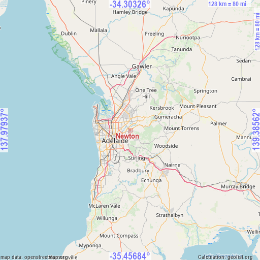
Newton GPS coordinates[2]
34° 52' 55.452" South, 138° 40' 56.964" East
| Map corner | latitude | longitude |
|---|---|---|
| Upper-left | -34.30326°, | 137.97937° |
| Center: | -34.88207°, | 138.68249° |
| Lower-right: | -35.45684°, | 139.38562° |
| Map W x H: | 128.3×128.3 km | = 79.7×79.7mi |
| max Lat: | -10.58257° ⇑67.6% North |
| Newton: | -34.88207° |
| min Lat: | ⇓32.4% South -43.31423° |
| min Long | Newton | max Long |
| 113.53327° | 138.68249° | 153.61246° |
| W 21.4%⇐ | ⇒78.6% E |
Elevation
Elevation of Newton is 96 m = 315 ft, and this is 26 m = 85 ft below average elevation for this country.
| Max E: |
1715 m = 5627 ft | 31% |
| Avg. | 122 m = 400 ft | |
| Newton | 96 m = 315 ft | |
Min E: |
-2 m = -7 ft | 69% |
See also: Australia elevation on elevation.city.
Geographical zone
Newton is located in South temperate zone (between Tropic of Capricorn and the Antarctic Circle). Distance of this Southern Tropic circle is 1272.6 km =790.8 mi to North.| Distance of | km | miles | from Newton |
|---|---|---|---|
| Equator | 3878.5 | 2410 | to North |
| Tropic Capricorn | 1272.6 | 790.8 | to North |
| Antarctic Circle | 3522.7 | 2188.9 | to South |
| South Pole | 6128.5 | 3808.1 | to South |


Nearby cities:
15 places around Newton: (largest is in red/bold)
• Athelstone
2.1 km =1.3 mi,  50°
50°
• Campbelltown
1.4 km =0.9 mi,  264°
264°
• Dernancourt
2.3 km =1.4 mi,  346°
346°
• Felixstow
3.3 km =2.1 mi, 256°
• Firle
3.7 km =2.3 mi,  226°
226°
• Glynde
3.1 km =1.9 mi,  240°
240°
• Hectorville
2.4 km =1.5 mi, 243°
• Highbury
3.5 km =2.2 mi,  22°
22°
• Holden Hill
3.5 km =2.2 mi,  344°
344°
• Magill
3.1 km =1.9 mi,  192°
192°
• Paradise
1.6 km =1 mi,  307°
307°
• Rostrevor
1.6 km =1 mi,  146°
146°
• Tranmere
3.2 km =2 mi,  215°
215°
• Windsor Gardens
3.7 km =2.3 mi,  299°
299°
• Woodforde
2.6 km =1.6 mi,  165°
165°
Sources, notices
• [Note1] Compared only with cities in Australia existing in our database
• [Src1] Map data: © OpenStreetMap contributors (CC-BY-SA)
• [Src2] Other city data from geonames.org with taken over terms of usage.
• [Src3] Geographical zone / Annual Mean Temperature by Robert A. Rohde @ Wikipedia
