Numurkah geodata
Numurkah (Victoria) is a populated place; located in Australia in Australia/Melbourne (GMT+11) time zone. With population of 4,396 people, there are 1651 cities with bigger population in this country. Compared to other cities in Australia, 78.7% of cities are located further ↑North; 60% of cities are located further →East and 71.5% of cities have lower elevation than Numurkah. Note1


Numurkah GPS coordinates[2]
36° 5' 18.456" South, 145° 26' 31.74" East
| Map corner | latitude | longitude |
|---|---|---|
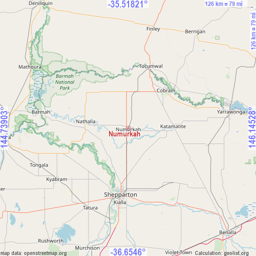
| Upper-left | -35.51821°, | 144.73903° |
| Center: | -36.08846°, | 145.44215° |
| Lower-right: | -36.6546°, | 146.14528° |
| Map W x H: | 126.4×126.4 km | = 78.5×78.5mi |
| max Lat: | -10.58257° ⇑78.7% North |
| Numurkah: | -36.08846° |
| min Lat: | ⇓21.3% South -43.31423° |
| min Long | Numurkah | max Long |
| 113.53327° | 145.44215° | 153.61246° |
| W 40%⇐ | ⇒60% E |
Elevation
Elevation of Numurkah is 110 m = 361 ft, and this is 12 m = 39 ft below average elevation for this country.
| Max E: |
1715 m = 5627 ft | 28.5% |
| Avg. | 122 m = 400 ft | |
| Numurkah | 110 m = 361 ft | |
Min E: |
-2 m = -7 ft | 71.5% |
See also: Australia elevation on elevation.city.
Geographical zone
Numurkah is located in South temperate zone (between Tropic of Capricorn and the Antarctic Circle). Distance of this Southern Tropic circle is 1406.7 km =874.1 mi to North.| Distance of | km | miles | from Numurkah |
|---|---|---|---|
| Equator | 4012.7 | 2493.4 | to North |
| Tropic Capricorn | 1406.7 | 874.1 | to North |
| Antarctic Circle | 3388.5 | 2105.5 | to South |
| South Pole | 5994.4 | 3724.7 | to South |


Nearby cities:
15 places around Numurkah: (largest is in red/bold)
• Barooga
30.5 km =19 mi,  48°
48°
• Cobram
25.8 km =16 mi,  43°
43°
• Congupna
23.5 km =14.6 mi,  181°
181°
• Grahamvale
28.9 km =18 mi, 181°
• Invergordon
15.4 km =9.6 mi,  124°
124°
• Katunga
8.7 km =5.4 mi,  16°
16°
• Kialla
40 km =24.9 mi, 183°
• Mooroopna
35.6 km =22.1 mi,  193°
193°
• Nathalia
21.7 km =13.5 mi,  279°
279°
• Shepparton
32.7 km =20.3 mi, 186°
• Shepparton East
35 km =21.7 mi,  174°
174°
• Strathmerton
18.4 km =11.4 mi,  10°
10°
• Tallygaroopna
18 km =11.2 mi, 182°
• Tocumwal
32.9 km =20.4 mi, 20°
• Yarroweyah
21 km =13 mi,  29°
29°
Sources, notices
• [Note1] Compared only with cities in Australia existing in our database
• [Src1] Map data: © OpenStreetMap contributors (CC-BY-SA)
• [Src2] Other city data from geonames.org with taken over terms of usage.
• [Src3] Geographical zone / Annual Mean Temperature by Robert A. Rohde @ Wikipedia
