New Berrima geodata
New Berrima (New South Wales) is a populated place; located in Australia in Australia/Sydney (GMT+11) time zone. With population of 582 people, there are 4619 cities with bigger population in this country. Compared to other cities in Australia, 63.4% of cities are located further ↑North; 58% of cities are located further ←West and 98.3% of cities have lower elevation than New Berrima. Note1


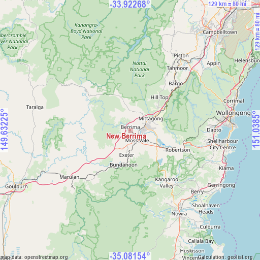
New Berrima GPS coordinates[2]
34° 30' 14.832" South, 150° 20' 7.332" East
| Map corner | latitude | longitude |
|---|---|---|
| Upper-left | -33.92268°, | 149.63225° |
| Center: | -34.50412°, | 150.33537° |
| Lower-right: | -35.08154°, | 151.0385° |
| Map W x H: | 128.9×128.9 km | = 80.1×80.1mi |
| max Lat: | -10.58257° ⇑63.4% North |
| New Berrima: | -34.50412° |
| min Lat: | ⇓36.6% South -43.31423° |
| min Long | New Berrima | max Long |
| 113.53327° | 150.33537° | 153.61246° |
| W 58%⇐ | ⇒42% E |
Elevation
Elevation of New Berrima is 692 m = 2270 ft, and this is 570 m = 1870 ft above average elevation for this country.
| Max E: |
1715 m = 5627 ft | 1.7% |
| New Berrima | 692 m 2270 ft | |
| Avg. | 122 m = 400 ft | |
Min E: |
-2 m = -7 ft | 98.3% |
See also: Australia elevation on elevation.city.
Geographical zone
New Berrima is located in South temperate zone (between Tropic of Capricorn and the Antarctic Circle). Distance of this Southern Tropic circle is 1230.6 km =764.7 mi to North.| Distance of | km | miles | from New Berrima |
|---|---|---|---|
| Equator | 3836.5 | 2383.9 | to North |
| Tropic Capricorn | 1230.6 | 764.7 | to North |
| Antarctic Circle | 3564.7 | 2215 | to South |
| South Pole | 6170.6 | 3834.2 | to South |


Nearby cities:
15 places around New Berrima: (largest is in red/bold)
• Berrima
1.9 km =1.2 mi,  10°
10°
• Bowral
8.3 km =5.2 mi,  69°
69°
• Bundanoon
17.3 km =10.7 mi,  191°
191°
• Burradoo
6.7 km =4.2 mi,  89°
89°
• Colo Vale
17.9 km =11.1 mi,  50°
50°
• Exeter
12.2 km =7.6 mi, 186°
• Hill Top
22.7 km =14.1 mi,  40°
40°
• Mittagong
11.8 km =7.3 mi,  59°
59°
• Moss Vale
6.4 km =4 mi,  149°
149°
• Renwick
13.8 km =8.6 mi, 63°
• Robertson
25.2 km =15.7 mi,  111°
111°
• Welby
11.3 km =7 mi, 50°
• Willow Vale
14.5 km =9 mi, 58°
• Wingello
26.7 km =16.6 mi,  217°
217°
• Yerrinbool
23.9 km =14.9 mi, 51°
Sources, notices
• [Note1] Compared only with cities in Australia existing in our database
• [Src1] Map data: © OpenStreetMap contributors (CC-BY-SA)
• [Src2] Other city data from geonames.org with taken over terms of usage.
• [Src3] Geographical zone / Annual Mean Temperature by Robert A. Rohde @ Wikipedia
