Hail Creek geodata
Hail Creek (Queensland) is a populated locality; located in Australia in Australia/Brisbane (GMT+10) time zone. With population of 602 people, there are 4563 cities with bigger population in this country. Compared to other cities in Australia, 92.8% of cities are located further ↓South; 51.6% of cities are located further ←West and 85.9% of cities have lower elevation than Hail Creek. Note1


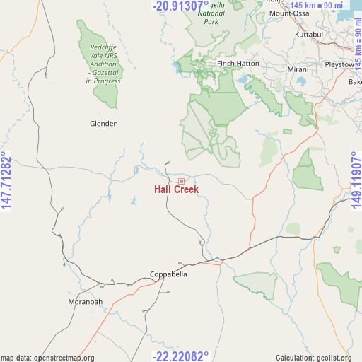
Hail Creek GPS coordinates[2]
21° 34' 6.312" South, 148° 24' 57.384" East
| Map corner | latitude | longitude |
|---|---|---|
| Upper-left | -20.91307°, | 147.71282° |
| Center: | -21.56842°, | 148.41594° |
| Lower-right: | -22.22082°, | 149.11907° |
| Map W x H: | 145.4×145.4 km | = 90.3×90.3mi |
| max Lat: | -10.58257° ⇑7.2% North |
| Hail Creek: | -21.56842° |
| min Lat: | ⇓92.8% South -43.31423° |
| min Long | Hail Creek | max Long |
| 113.53327° | 148.41594° | 153.61246° |
| W 51.6%⇐ | ⇒48.4% E |
Elevation
Elevation of Hail Creek is 264 m = 866 ft, and this is 142 m = 466 ft above average elevation for this country.
| Max E: |
1715 m = 5627 ft | 14.1% |
| Hail Creek | 264 m 866 ft | |
| Avg. | 122 m = 400 ft | |
Min E: |
-2 m = -7 ft | 85.9% |
See also: Australia elevation on elevation.city.
Geographical zone
Hail Creek is located in South Torrid zone (between Equator and Tropic of Capricorn). Distance of this Southern Tropic circle is 207.7 km =129.1 mi to South.| Distance of | km | miles | from Hail Creek |
|---|---|---|---|
| Equator | 2398.2 | 1490.2 | to North |
| Tropic Capricorn | 207.7 | 129.1 | to South |
| Antarctic Circle | 5003 | 3108.7 | to South |
| South Pole | 7608.9 | 4727.9 | to South |


Nearby cities:
15 places around Hail Creek: (largest is in red/bold)
• Alligator Creek
85.2 km =52.9 mi,  72°
72°
• Bakers Creek
85 km =52.8 mi,  62°
62°
• Coppabella
43.8 km =27.2 mi,  195°
195°
• Eton
66.8 km =41.5 mi, 59°
• Finch Hatton
52.4 km =32.6 mi,  24°
24°
• Glenden
39.2 km =24.4 mi,  307°
307°
• Hampden
77.4 km =48.1 mi,  43°
43°
• Kuttabul
77.8 km =48.3 mi, 40°
• Marian
72.1 km =44.8 mi,  49°
49°
• Mirani
65 km =40.4 mi, 45°
• Moranbah
61.4 km =38.2 mi,  218°
218°
• Nebo
30.4 km =18.9 mi,  114°
114°
• Sarina
84.5 km =52.5 mi,  78°
78°
• The Leap
82.3 km =51.1 mi, 49°
• Walkerston
80.5 km =50 mi, 55°
Sources, notices
• [Note1] Compared only with cities in Australia existing in our database
• [Src1] Map data: © OpenStreetMap contributors (CC-BY-SA)
• [Src2] Other city data from geonames.org with taken over terms of usage.
• [Src3] Geographical zone / Annual Mean Temperature by Robert A. Rohde @ Wikipedia
