Moranbah geodata
Moranbah (Queensland) is a populated place; located in Australia in Australia/Brisbane (GMT+10) time zone. With population of 12,068 people, there are 404 cities with bigger population in this country. Compared to other cities in Australia, 92.6% of cities are located further ↓South; 51% of cities are located further ←West and 85.6% of cities have lower elevation than Moranbah. Note1


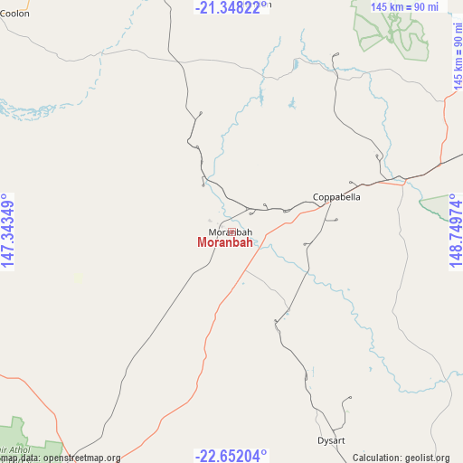
Moranbah GPS coordinates[2]
22° 0' 5.868" South, 148° 2' 47.796" East
| Map corner | latitude | longitude |
|---|---|---|
| Upper-left | -21.34822°, | 147.34349° |
| Center: | -22.00163°, | 148.04661° |
| Lower-right: | -22.65204°, | 148.74974° |
| Map W x H: | 145×145 km | = 90.1×90.1mi |
| max Lat: | -10.58257° ⇑7.4% North |
| Moranbah: | -22.00163° |
| min Lat: | ⇓92.6% South -43.31423° |
| min Long | Moranbah | max Long |
| 113.53327° | 148.04661° | 153.61246° |
| W 51%⇐ | ⇒49% E |
Elevation
Elevation of Moranbah is 257 m = 843 ft, and this is 135 m = 443 ft above average elevation for this country.
| Max E: |
1715 m = 5627 ft | 14.4% |
| Moranbah | 257 m 843 ft | |
| Avg. | 122 m = 400 ft | |
Min E: |
-2 m = -7 ft | 85.6% |
See also: Australia elevation on elevation.city.
Geographical zone
Moranbah is located in South Torrid zone (between Equator and Tropic of Capricorn). Distance of this Southern Tropic circle is 159.6 km =99.2 mi to South.| Distance of | km | miles | from Moranbah |
|---|---|---|---|
| Equator | 2446.4 | 1520.1 | to North |
| Tropic Capricorn | 159.6 | 99.2 | to South |
| Antarctic Circle | 4954.8 | 3078.8 | to South |
| South Pole | 7560.7 | 4698 | to South |


Nearby cities:
15 places around Moranbah: (largest is in red/bold)
• Capella
120.6 km =74.9 mi,  181°
181°
• Clermont
100.7 km =62.6 mi,  204°
204°
• Coppabella
26.9 km =16.7 mi,  76°
76°
• Dysart
72.3 km =44.9 mi,  154°
154°
• Eton
126 km =78.3 mi,  49°
49°
• Finch Hatton
113.1 km =70.3 mi,  32°
32°
• Glenden
72.3 km =44.9 mi,  5°
5°
• Hail Creek
61.4 km =38.2 mi,  38°
38°
• Koumala
131.4 km =81.6 mi,  70°
70°
• Marian
132.9 km =82.6 mi, 44°
• Middlemount
112.4 km =69.8 mi,  143°
143°
• Mirani
126.2 km =78.4 mi, 41°
• Nebo
74.6 km =46.4 mi,  61°
61°
• Sarina
137.1 km =85.2 mi, 61°
• Tieri
119.3 km =74.1 mi,  165°
165°
Sources, notices
• [Note1] Compared only with cities in Australia existing in our database
• [Src1] Map data: © OpenStreetMap contributors (CC-BY-SA)
• [Src2] Other city data from geonames.org with taken over terms of usage.
• [Src3] Geographical zone / Annual Mean Temperature by Robert A. Rohde @ Wikipedia
