Coppabella geodata
Coppabella (Queensland) is a section of populated place; located in Australia in Australia/Brisbane (GMT+10) time zone. With population of 1,946 people, there are 2943 cities with bigger population in this country. Compared to other cities in Australia, 92.7% of cities are located further ↓South; 51.4% of cities are located further ←West and 84.8% of cities have lower elevation than Coppabella. Note1


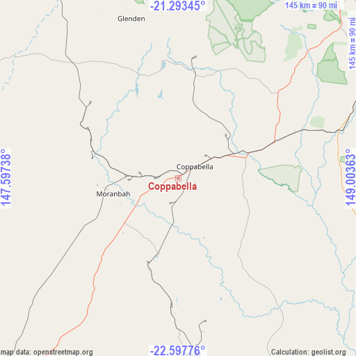
Coppabella GPS coordinates[2]
21° 56' 49.56" South, 148° 18' 1.8" East
| Map corner | latitude | longitude |
|---|---|---|
| Upper-left | -21.29345°, | 147.59738° |
| Center: | -21.9471°, | 148.3005° |
| Lower-right: | -22.59776°, | 149.00363° |
| Map W x H: | 145×145 km | = 90.1×90.1mi |
| max Lat: | -10.58257° ⇑7.3% North |
| Coppabella: | -21.9471° |
| min Lat: | ⇓92.7% South -43.31423° |
| min Long | Coppabella | max Long |
| 113.53327° | 148.3005° | 153.61246° |
| W 51.4%⇐ | ⇒48.6% E |
Elevation
Elevation of Coppabella is 244 m = 801 ft, and this is 122 m = 400 ft above average elevation for this country.
| Max E: |
1715 m = 5627 ft | 15.2% |
| Coppabella | 244 m 801 ft | |
| Avg. | 122 m = 400 ft | |
Min E: |
-2 m = -7 ft | 84.8% |
See also: Australia elevation on elevation.city.
Geographical zone
Coppabella is located in South Torrid zone (between Equator and Tropic of Capricorn). Distance of this Southern Tropic circle is 165.6 km =102.9 mi to South.| Distance of | km | miles | from Coppabella |
|---|---|---|---|
| Equator | 2440.3 | 1516.3 | to North |
| Tropic Capricorn | 165.6 | 102.9 | to South |
| Antarctic Circle | 4960.9 | 3082.6 | to South |
| South Pole | 7566.8 | 4701.8 | to South |


Nearby cities:
15 places around Coppabella: (largest is in red/bold)
• Alligator Creek
115.3 km =71.6 mi,  53°
53°
• Armstrong Beach
116.2 km =72.2 mi,  61°
61°
• Dysart
71.5 km =44.4 mi,  175°
175°
• Eton
102.9 km =63.9 mi,  42°
42°
• Finch Hatton
95.9 km =59.6 mi,  20°
20°
• Glenden
68.6 km =42.6 mi,  343°
343°
• Hail Creek
43.8 km =27.2 mi, 15°
• Koumala
104.7 km =65.1 mi,  69°
69°
• Marian
111.3 km =69.2 mi, 36°
• Middlemount
104.6 km =65 mi,  156°
156°
• Mirani
105.3 km =65.4 mi,  33°
33°
• Moranbah
26.9 km =16.7 mi,  256°
256°
• Nebo
49.2 km =30.6 mi, 53°
• Sarina
111.4 km =69.2 mi, 58°
• Walkerston
117.4 km =72.9 mi, 41°
Sources, notices
• [Note1] Compared only with cities in Australia existing in our database
• [Src1] Map data: © OpenStreetMap contributors (CC-BY-SA)
• [Src2] Other city data from geonames.org with taken over terms of usage.
• [Src3] Geographical zone / Annual Mean Temperature by Robert A. Rohde @ Wikipedia
