Nebo geodata
Nebo (Queensland) is a populated place; located in Australia in Australia/Brisbane (GMT+10) time zone. With population of 1,085 people, there are 3717 cities with bigger population in this country. Compared to other cities in Australia, 92.7% of cities are located further ↓South; 52% of cities are located further ←West and 82.3% of cities have lower elevation than Nebo. Note1


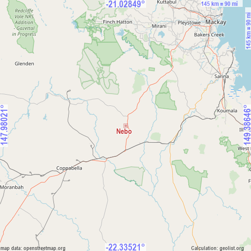
Nebo GPS coordinates[2]
21° 40' 59.988" South, 148° 40' 59.988" East
| Map corner | latitude | longitude |
|---|---|---|
| Upper-left | -21.02849°, | 147.98021° |
| Center: | -21.68333°, | 148.68333° |
| Lower-right: | -22.33521°, | 149.38646° |
| Map W x H: | 145.3×145.3 km | = 90.3×90.3mi |
| max Lat: | -10.58257° ⇑7.3% North |
| Nebo: | -21.68333° |
| min Lat: | ⇓92.7% South -43.31423° |
| min Long | Nebo | max Long |
| 113.53327° | 148.68333° | 153.61246° |
| W 52%⇐ | ⇒48% E |
Elevation
Elevation of Nebo is 209 m = 686 ft, and this is 87 m = 285 ft above average elevation for this country.
| Max E: |
1715 m = 5627 ft | 17.7% |
| Nebo | 209 m 686 ft | |
| Avg. | 122 m = 400 ft | |
Min E: |
-2 m = -7 ft | 82.3% |
See also: Australia elevation on elevation.city.
Geographical zone
Nebo is located in South Torrid zone (between Equator and Tropic of Capricorn). Distance of this Southern Tropic circle is 195 km =121.2 mi to South.| Distance of | km | miles | from Nebo |
|---|---|---|---|
| Equator | 2411 | 1498.1 | to North |
| Tropic Capricorn | 195 | 121.2 | to South |
| Antarctic Circle | 4990.2 | 3100.8 | to South |
| South Pole | 7596.1 | 4720 | to South |


Nearby cities:
15 places around Nebo: (largest is in red/bold)
• Alligator Creek
66.1 km =41.1 mi,  53°
53°
• Armstrong Beach
67.8 km =42.1 mi,  67°
67°
• Bakers Creek
70.4 km =43.7 mi,  42°
42°
• Coppabella
49.2 km =30.6 mi,  233°
233°
• Eton
55.3 km =34.4 mi,  32°
32°
• Finch Hatton
60.6 km =37.7 mi,  354°
354°
• Glenden
69.2 km =43 mi,  301°
301°
• Hail Creek
30.4 km =18.9 mi,  294°
294°
• Hampden
73.3 km =45.5 mi,  20°
20°
• Koumala
59 km =36.7 mi,  82°
82°
• Marian
65.7 km =40.8 mi, 24°
• Mirani
61.3 km =38.1 mi, 17°
• Sarina
62.5 km =38.8 mi,  61°
61°
• Sarina Beach
72.5 km =45 mi, 63°
• Walkerston
69.8 km =43.4 mi, 33°
Sources, notices
• [Note1] Compared only with cities in Australia existing in our database
• [Src1] Map data: © OpenStreetMap contributors (CC-BY-SA)
• [Src2] Other city data from geonames.org with taken over terms of usage.
• [Src3] Geographical zone / Annual Mean Temperature by Robert A. Rohde @ Wikipedia
