Avşar geodata
Avşar (Ağcabǝdi) is a populated place; located in Azerbaijan in Asia/Baku (GMT+4) time zone. With population of 5,600 people, there are 107 cities with bigger population in this country. Compared to other cities in Azerbaijan, 68.6% of cities are located further ↑North; 53% of cities are located further →East and 61.1% of cities have higher elevation than Avşar. Note1


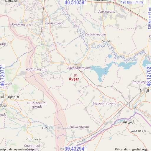
Avşar GPS coordinates[2]
39° 58' 26.004" North, 47° 25' 26.004" East
| Map corner | latitude | longitude |
|---|---|---|
| Upper-left | 40.51059°, | 46.72077° |
| Center: | 39.97389°, | 47.42389° |
| Lower-right: | 39.43294°, | 48.12702° |
| Map W x H: | 119.8×119.8 km | = 74.4×74.4mi |
| max Lat: | 41.75259° ⇑68.6% North |
| Avşar: | 39.97389° |
| min Lat: | ⇓31.4% South 38.45598° |
| min Long | Avşar | max Long |
| 44.84846° | 47.42389° | 50.84003° |
| W 47%⇐ | ⇒53% E |
Elevation
Elevation of Avşar is 45 m = 148 ft, and this is 338 m = 1109 ft below average elevation for this country.
| Max E: |
2211 m = 7254 ft | 61.1% |
| Avg. | 383 m = 1257 ft | |
| Avşar | 45 m = 148 ft | |
Min E: |
-26 m = -85 ft | 38.9% |
See also: Azerbaijan elevation on elevation.city.
Geographical zone
Avşar is located in North temperate zone (between Tropic of Cancer and the Arctic Circle). Distance of this Northern Tropic circle is 1838.8 km =1142.6 mi to South.| Distance of | km | miles | from Avşar |
|---|---|---|---|
| North Pole | 5562.4 | 3456.3 | to North |
| Arctic Circle | 2956.5 | 1837.1 | to North |
| Tropic Cancer | 1838.8 | 1142.6 | to South |
| Equator | 4444.7 | 2761.8 | to South |


Nearby cities:
15 places around Avşar: (largest is in red/bold)
• Agdzhabedy
9 km =5.6 mi,  19°
19°
• Askyaran
50.6 km =31.4 mi,  265°
265°
• Ağdam
42.3 km =26.3 mi, 272°
• Barda
51.3 km =31.9 mi,  330°
330°
• Begimli
45.9 km =28.5 mi,  47°
47°
• Beylagan
27.6 km =17.1 mi,  143°
143°
• Birinci Aşıqlı
27.8 km =17.3 mi,  128°
128°
• Dünyamalılar
36.3 km =22.6 mi, 128°
• Fizuli
47.8 km =29.7 mi,  209°
209°
• Novyy Karanlug
33.2 km =20.6 mi,  233°
233°
• Orjonikidze
44.9 km =27.9 mi,  146°
146°
• Qırmızı Bazar
52.2 km =32.4 mi, 230°
• Xocalı
54.4 km =33.8 mi,  262°
262°
• Yuxarı Aran
33.2 km =20.6 mi, 143°
• Zardob
36.6 km =22.7 mi,  42°
42°
Sources, notices
• [Note1] Compared only with cities in Azerbaijan existing in our database
• [Src1] Map data: © OpenStreetMap contributors (CC-BY-SA)
• [Src2] Other city data from geonames.org with taken over terms of usage.
• [Src3] Geographical zone / Annual Mean Temperature by Robert A. Rohde @ Wikipedia
