Zardob geodata
Zardob (Zərdab) is a seat of a first-order administrative division; located in Azerbaijan in Asia/Baku (GMT+4) time zone. With population of 10,612 people, there are 69 cities with bigger population in this country. Compared to other cities in Azerbaijan, 62.7% of cities are located further ↑North; 51.9% of cities are located further ←West and 81.1% of cities have higher elevation than Zardob. Note1


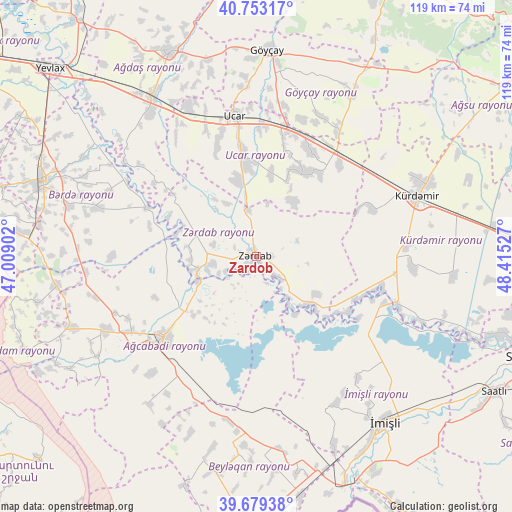
Zardob GPS coordinates[2]
40° 13' 6.24" North, 47° 42' 43.704" East
| Map corner | latitude | longitude |
|---|---|---|
| Upper-left | 40.75317°, | 47.00902° |
| Center: | 40.2184°, | 47.71214° |
| Lower-right: | 39.67938°, | 48.41527° |
| Map W x H: | 119.4×119.4 km | = 74.2×74.2mi |
| max Lat: | 41.75259° ⇑62.7% North |
| Zardob: | 40.2184° |
| min Lat: | ⇓37.3% South 38.45598° |
| min Long | Zardob | max Long |
| 44.84846° | 47.71214° | 50.84003° |
| W 51.9%⇐ | ⇒48.1% E |
Elevation
Elevation of Zardob is 2 m = 7 ft, and this is 381 m = 1250 ft below average elevation for this country.
| Max E: |
2211 m = 7254 ft | 81.1% |
| Avg. | 383 m = 1257 ft | |
| Zardob | 2 m = 7 ft | |
Min E: |
-26 m = -85 ft | 18.9% |
See also: Azerbaijan elevation on elevation.city.
Geographical zone
Zardob is located in North temperate zone (between Tropic of Cancer and the Arctic Circle). Distance of this Northern Tropic circle is 1865.9 km =1159.4 mi to South.| Distance of | km | miles | from Zardob |
|---|---|---|---|
| North Pole | 5535.2 | 3439.4 | to North |
| Arctic Circle | 2929.3 | 1820.2 | to North |
| Tropic Cancer | 1865.9 | 1159.4 | to South |
| Equator | 4471.9 | 2778.7 | to South |


Nearby cities:
15 places around Zardob: (largest is in red/bold)
• Agdzhabedy
28.5 km =17.7 mi,  228°
228°
• Avşar
36.6 km =22.7 mi,  222°
222°
• Ağdaş
51.7 km =32.1 mi,  337°
337°
• Barda
52.7 km =32.7 mi,  289°
289°
• Begimli
10.1 km =6.3 mi,  68°
68°
• Beylagan
49.9 km =31 mi,  189°
189°
• Birinci Aşıqlı
44.5 km =27.7 mi,  183°
183°
• Dünyamalılar
49.7 km =30.9 mi, 175°
• Geoktschai
48.1 km =29.9 mi,  3°
3°
• Imishli
48.7 km =30.3 mi,  142°
142°
• Kyurdarmir
40.1 km =24.9 mi, 69°
• Saatlı
64.3 km =40 mi,  119°
119°
• Samuxlu
56.1 km =34.9 mi,  305°
305°
• Ujar
33.8 km =21 mi,  351°
351°
• Yuxarı Aran
54.1 km =33.6 mi, 185°
Sources, notices
• [Note1] Compared only with cities in Azerbaijan existing in our database
• [Src1] Map data: © OpenStreetMap contributors (CC-BY-SA)
• [Src2] Other city data from geonames.org with taken over terms of usage.
• [Src3] Geographical zone / Annual Mean Temperature by Robert A. Rohde @ Wikipedia
