Xocalı geodata
Xocalı is a seat of a first-order administrative division; located in Azerbaijan in Asia/Baku (GMT+4) time zone. With population of 5,810 people, there are 105 cities with bigger population in this country. Compared to other cities in Azerbaijan, 71.4% of cities are located further ↑North; 66.5% of cities are located further →East and 70.3% of cities have lower elevation than Xocalı. Note1


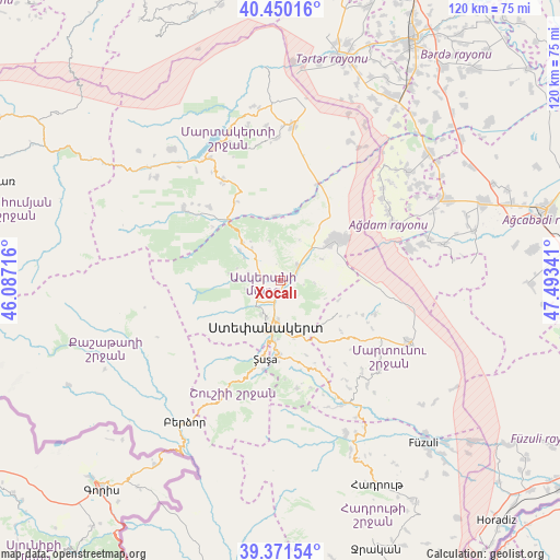
Xocalı GPS coordinates[2]
39° 54' 46.692" North, 46° 47' 25.008" East
| Map corner | latitude | longitude |
|---|---|---|
| Upper-left | 40.45016°, | 46.08716° |
| Center: | 39.91297°, | 46.79028° |
| Lower-right: | 39.37154°, | 47.49341° |
| Map W x H: | 119.9×119.9 km | = 74.5×74.5mi |
| max Lat: | 41.75259° ⇑71.4% North |
| Xocalı: | 39.91297° |
| min Lat: | ⇓28.6% South 38.45598° |
| min Long | Xocalı | max Long |
| 44.84846° | 46.79028° | 50.84003° |
| W 33.5%⇐ | ⇒66.5% E |
Elevation
Elevation of Xocalı is 582 m = 1909 ft, and this is 199 m = 653 ft above average elevation for this country.
| Max E: |
2211 m = 7254 ft | 29.7% |
| Xocalı | 582 m 1909 ft | |
| Avg. | 383 m = 1257 ft | |
Min E: |
-26 m = -85 ft | 70.3% |
See also: Azerbaijan elevation on elevation.city.
Geographical zone
Xocalı is located in North temperate zone (between Tropic of Cancer and the Arctic Circle). Distance of this Northern Tropic circle is 1832 km =1138.4 mi to South.| Distance of | km | miles | from Xocalı |
|---|---|---|---|
| North Pole | 5569.2 | 3460.5 | to North |
| Arctic Circle | 2963.3 | 1841.3 | to North |
| Tropic Cancer | 1832 | 1138.4 | to South |
| Equator | 4437.9 | 2757.6 | to South |


Nearby cities:
15 places around Xocalı: (largest is in red/bold)
• Agdzhabedy
59 km =36.7 mi,  75°
75°
• Askyaran
4.6 km =2.9 mi,  50°
50°
• Avşar
54.4 km =33.8 mi, 82°
• Ağdam
14.6 km =9.1 mi, 53°
• Barda
58.8 km =36.5 mi,  29°
29°
• Fizuli
46.1 km =28.6 mi,  138°
138°
• Hadrut
48.3 km =30 mi,  154°
154°
• Laçın
40.5 km =25.2 mi,  210°
210°
• Martakert
33.3 km =20.7 mi,  4°
4°
• Novyy Karanlug
30.4 km =18.9 mi,  115°
115°
• Qırmızı Bazar
29.7 km =18.5 mi, 152°
• Shushi
17.3 km =10.7 mi,  191°
191°
• Terter
49.2 km =30.6 mi,  14°
14°
• Vank
26.1 km =16.2 mi,  306°
306°
• Xankandi
11.1 km =6.9 mi,  196°
196°
Sources, notices
• [Note1] Compared only with cities in Azerbaijan existing in our database
• [Src1] Map data: © OpenStreetMap contributors (CC-BY-SA)
• [Src2] Other city data from geonames.org with taken over terms of usage.
• [Src3] Geographical zone / Annual Mean Temperature by Robert A. Rohde @ Wikipedia
