Begimli geodata
Begimli (Zərdab) is a populated place; located in Azerbaijan in Asia/Baku (GMT+4) time zone. With population of 830 people, there are 179 cities with bigger population in this country. Compared to other cities in Azerbaijan, 61.6% of cities are located further ↑North; 53.5% of cities are located further ←West and 84.9% of cities have higher elevation than Begimli. Note1


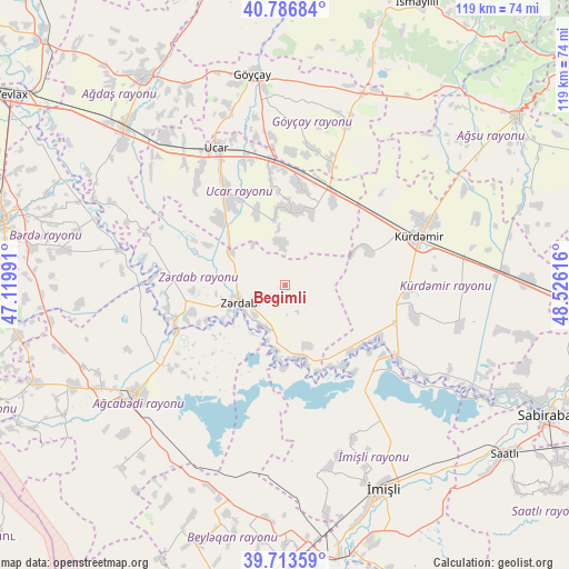
Begimli GPS coordinates[2]
40° 15' 8.424" North, 47° 49' 22.908" East
| Map corner | latitude | longitude |
|---|---|---|
| Upper-left | 40.78684°, | 47.11991° |
| Center: | 40.25234°, | 47.82303° |
| Lower-right: | 39.71359°, | 48.52616° |
| Map W x H: | 119.3×119.3 km | = 74.1×74.1mi |
| max Lat: | 41.75259° ⇑61.6% North |
| Begimli: | 40.25234° |
| min Lat: | ⇓38.4% South 38.45598° |
| min Long | Begimli | max Long |
| 44.84846° | 47.82303° | 50.84003° |
| W 53.5%⇐ | ⇒46.5% E |
Elevation
Elevation of Begimli is -4 m = -13 ft, and this is 387 m = 1270 ft below average elevation for this country.
| Max E: |
2211 m = 7254 ft | 84.9% |
| Avg. | 383 m = 1257 ft | |
| Begimli | -4 m = -13 ft | |
Min E: |
-26 m = -85 ft | 15.1% |
See also: Azerbaijan elevation on elevation.city.
Geographical zone
Begimli is located in North temperate zone (between Tropic of Cancer and the Arctic Circle). Distance of this Northern Tropic circle is 1869.7 km =1161.8 mi to South.| Distance of | km | miles | from Begimli |
|---|---|---|---|
| North Pole | 5531.4 | 3437.1 | to North |
| Arctic Circle | 2925.5 | 1817.8 | to North |
| Tropic Cancer | 1869.7 | 1161.8 | to South |
| Equator | 4475.6 | 2781 | to South |


Nearby cities:
15 places around Begimli: (largest is in red/bold)
• Agdzhabedy
38.2 km =23.7 mi,  233°
233°
• Aghsu
60.4 km =37.5 mi,  54°
54°
• Avşar
45.9 km =28.5 mi, 227°
• Ağdaş
52.9 km =32.9 mi,  326°
326°
• Barda
60.7 km =37.7 mi,  283°
283°
• Beylagan
55.8 km =34.7 mi,  198°
198°
• Birinci Aşıqlı
49.7 km =30.9 mi,  194°
194°
• Dünyamalılar
53.6 km =33.3 mi, 185°
• Geoktschai
44.8 km =27.8 mi,  351°
351°
• Imishli
47 km =29.2 mi,  154°
154°
• Kyurdarmir
30 km =18.6 mi,  70°
70°
• Saatlı
58.5 km =36.4 mi,  127°
127°
• Ujar
32.9 km =20.4 mi, 334°
• Yuxarı Aran
59.4 km =36.9 mi, 193°
• Zardob
10.1 km =6.3 mi,  248°
248°
Sources, notices
• [Note1] Compared only with cities in Azerbaijan existing in our database
• [Src1] Map data: © OpenStreetMap contributors (CC-BY-SA)
• [Src2] Other city data from geonames.org with taken over terms of usage.
• [Src3] Geographical zone / Annual Mean Temperature by Robert A. Rohde @ Wikipedia
