Barda geodata
Barda (Bǝrdǝ) is a seat of a first-order administrative division; located in Azerbaijan in Asia/Baku (GMT+4) time zone. With population of 37,372 people, there are 17 cities with bigger population in this country. Compared to other cities in Azerbaijan, 55.1% of cities are located further ↑North; 56.2% of cities are located further →East and 54.6% of cities have higher elevation than Barda. Note1


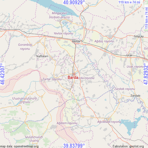
Barda GPS coordinates[2]
40° 22' 32.772" North, 47° 7' 34.284" East
| Map corner | latitude | longitude |
|---|---|---|
| Upper-left | 40.90929°, | 46.42307° |
| Center: | 40.37577°, | 47.12619° |
| Lower-right: | 39.83799°, | 47.82932° |
| Map W x H: | 119.1×119.1 km | = 74×74mi |
| max Lat: | 41.75259° ⇑55.1% North |
| Barda: | 40.37577° |
| min Lat: | ⇓44.9% South 38.45598° |
| min Long | Barda | max Long |
| 44.84846° | 47.12619° | 50.84003° |
| W 43.8%⇐ | ⇒56.2% E |
Elevation
Elevation of Barda is 77 m = 253 ft, and this is 306 m = 1004 ft below average elevation for this country.
| Max E: |
2211 m = 7254 ft | 54.6% |
| Avg. | 383 m = 1257 ft | |
| Barda | 77 m = 253 ft | |
Min E: |
-26 m = -85 ft | 45.4% |
See also: Azerbaijan elevation on elevation.city.
Geographical zone
Barda is located in North temperate zone (between Tropic of Cancer and the Arctic Circle). Distance of this Northern Tropic circle is 1883.4 km =1170.3 mi to South.| Distance of | km | miles | from Barda |
|---|---|---|---|
| North Pole | 5517.7 | 3428.5 | to North |
| Arctic Circle | 2911.8 | 1809.3 | to North |
| Tropic Cancer | 1883.4 | 1170.3 | to South |
| Equator | 4489.4 | 2789.6 | to South |


Nearby cities:
15 places around Barda: (largest is in red/bold)
• Agdzhabedy
45.9 km =28.5 mi,  141°
141°
• Aran
30.5 km =19 mi,  335°
335°
• Ağdam
46 km =28.6 mi,  201°
201°
• Ağdaş
42.1 km =26.2 mi,  44°
44°
• Goranboy
38.6 km =24 mi,  312°
312°
• Martakert
31.7 km =19.7 mi,  234°
234°
• Mingelchaur
43.5 km =27 mi,  352°
352°
• Naftalan
29.8 km =18.5 mi,  299°
299°
• Qaramanlı
16.3 km =10.1 mi,  316°
316°
• Qazanbulaq
48.5 km =30.1 mi, 303°
• Qızılhacılı
31.9 km =19.8 mi, 314°
• Samuxlu
15.1 km =9.4 mi,  14°
14°
• Terter
16.9 km =10.5 mi,  257°
257°
• Ujar
47.4 km =29.5 mi,  70°
70°
• Yevlakh
27 km =16.8 mi,  4°
4°
In other languages:
- In Spanish: Bərdə
- In German: Bərdə
- In Italian: Bərdə
- In Russian: Барда
- In Chinese: 巴爾達
Sources, notices
• [Note1] Compared only with cities in Azerbaijan existing in our database
• [Src1] Map data: © OpenStreetMap contributors (CC-BY-SA)
• [Src2] Other city data from geonames.org with taken over terms of usage.
• [Src3] Geographical zone / Annual Mean Temperature by Robert A. Rohde @ Wikipedia
