Qaraçuxur geodata
Qaraçuxur (Baki) is a populated place; located in Azerbaijan in Asia/Baku (GMT+4) time zone. With population of 72,989 people, there are 7 cities with bigger population in this country. Compared to other cities in Azerbaijan, 54.1% of cities are located further ↑North; 91.4% of cities are located further ←West and 58.4% of cities have higher elevation than Qaraçuxur. Note1


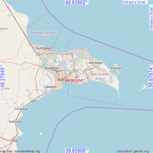
Qaraçuxur GPS coordinates[2]
40° 23' 48.012" North, 49° 58' 24.996" East
| Map corner | latitude | longitude |
|---|---|---|
| Upper-left | 40.93002°, | 49.27049° |
| Center: | 40.39667°, | 49.97361° |
| Lower-right: | 39.85906°, | 50.67674° |
| Map W x H: | 119.1×119.1 km | = 74×74mi |
| max Lat: | 41.75259° ⇑54.1% North |
| Qaraçuxur: | 40.39667° |
| min Lat: | ⇓45.9% South 38.45598° |
| min Long | Qaraçuxur | max Long |
| 44.84846° | 49.97361° | 50.84003° |
| W 91.4%⇐ | ⇒8.6% E |
Elevation
Elevation of Qaraçuxur is 51 m = 167 ft, and this is 332 m = 1089 ft below average elevation for this country.
| Max E: |
2211 m = 7254 ft | 58.4% |
| Avg. | 383 m = 1257 ft | |
| Qaraçuxur | 51 m = 167 ft | |
Min E: |
-26 m = -85 ft | 41.6% |
See also: Qaraçuxur elevation on elevation.city.
Geographical zone
Qaraçuxur is located in North temperate zone (between Tropic of Cancer and the Arctic Circle). Distance of this Northern Tropic circle is 1885.8 km =1171.8 mi to South.| Distance of | km | miles | from Qaraçuxur |
|---|---|---|---|
| North Pole | 5515.4 | 3427.1 | to North |
| Arctic Circle | 2909.5 | 1807.9 | to North |
| Tropic Cancer | 1885.8 | 1171.8 | to South |
| Equator | 4491.7 | 2791 | to South |


Nearby cities:
15 places around Qaraçuxur: (largest is in red/bold)
• Amirdzhan
3.4 km =2.1 mi,  14°
14°
• Badamdar
15.6 km =9.7 mi,  246°
246°
• Baku
7.2 km =4.5 mi, 253°
• Bakıxanov
2.5 km =1.6 mi,  347°
347°
• Balakhani
8.7 km =5.4 mi,  328°
328°
• Bilajari
15.2 km =9.4 mi,  290°
290°
• Binagadi
14.5 km =9 mi,  302°
302°
• Biny Selo
11.3 km =7 mi,  57°
57°
• Digah
13.6 km =8.5 mi,  321°
321°
• Hövsan
9.8 km =6.1 mi,  104°
104°
• Maştağa
15.1 km =9.4 mi, 10°
• Ramana
5.1 km =3.2 mi, 6°
• Sabunçu
5.5 km =3.4 mi,  337°
337°
• Yeni Suraxanı
6.5 km =4 mi,  54°
54°
• Zabrat
9.4 km =5.8 mi, 343°
Sources, notices
• [Note1] Compared only with cities in Azerbaijan existing in our database
• [Src1] Map data: © OpenStreetMap contributors (CC-BY-SA)
• [Src2] Other city data from geonames.org with taken over terms of usage.
• [Src3] Geographical zone / Annual Mean Temperature by Robert A. Rohde @ Wikipedia
