Balakhani geodata
Balakhani (Baki) is a populated place; located in Azerbaijan in Asia/Baku (GMT+4) time zone. With population of 10,863 people, there are 67 cities with bigger population in this country. Compared to other cities in Azerbaijan, 53% of cities are located further ↓South; 89.2% of cities are located further ←West and 56.8% of cities have higher elevation than Balakhani. Note1


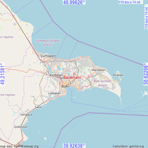
Balakhani GPS coordinates[2]
40° 27' 48.384" North, 49° 55' 8.148" East
| Map corner | latitude | longitude |
|---|---|---|
| Upper-left | 40.99626°, | 49.21581° |
| Center: | 40.46344°, | 49.91893° |
| Lower-right: | 39.92636°, | 50.62206° |
| Map W x H: | 119×119 km | = 73.9×73.9mi |
| max Lat: | 41.75259° ⇑47% North |
| Balakhani: | 40.46344° |
| min Lat: | ⇓53% South 38.45598° |
| min Long | Balakhani | max Long |
| 44.84846° | 49.91893° | 50.84003° |
| W 89.2%⇐ | ⇒10.8% E |
Elevation
Elevation of Balakhani is 57 m = 187 ft, and this is 326 m = 1070 ft below average elevation for this country.
| Max E: |
2211 m = 7254 ft | 56.8% |
| Avg. | 383 m = 1257 ft | |
| Balakhani | 57 m = 187 ft | |
Min E: |
-26 m = -85 ft | 43.2% |
See also: Azerbaijan elevation on elevation.city.
Geographical zone
Balakhani is located in North temperate zone (between Tropic of Cancer and the Arctic Circle). Distance of this Northern Tropic circle is 1893.2 km =1176.4 mi to South.| Distance of | km | miles | from Balakhani |
|---|---|---|---|
| North Pole | 5507.9 | 3422.4 | to North |
| Arctic Circle | 2902.1 | 1803.3 | to North |
| Tropic Cancer | 1893.2 | 1176.4 | to South |
| Equator | 4499.1 | 2795.6 | to South |


Nearby cities:
15 places around Balakhani: (largest is in red/bold)
• Amirdzhan
6.9 km =4.3 mi,  126°
126°
• Baku
9.8 km =6.1 mi,  193°
193°
• Bakıxanov
6.4 km =4 mi,  140°
140°
• Bilajari
9.8 km =6.1 mi,  257°
257°
• Binagadi
7.7 km =4.8 mi,  272°
272°
• Digah
4.9 km =3 mi,  310°
310°
• Khirdalan
14 km =8.7 mi, 262°
• Khodzhi-Gasan
13.9 km =8.6 mi,  246°
246°
• Maştağa
10.4 km =6.5 mi,  44°
44°
• Nardaran
12.6 km =7.8 mi, 35°
• Qaraçuxur
8.7 km =5.4 mi,  148°
148°
• Ramana
5.7 km =3.5 mi,  114°
114°
• Sabunçu
3.4 km =2.1 mi, 133°
• Yeni Suraxanı
10.6 km =6.6 mi, 110°
• Zabrat
2.5 km =1.6 mi,  51°
51°
Sources, notices
• [Note1] Compared only with cities in Azerbaijan existing in our database
• [Src1] Map data: © OpenStreetMap contributors (CC-BY-SA)
• [Src2] Other city data from geonames.org with taken over terms of usage.
• [Src3] Geographical zone / Annual Mean Temperature by Robert A. Rohde @ Wikipedia
