Biny Selo geodata
Biny Selo (Baki) is a populated place; located in Azerbaijan in Asia/Baku (GMT+4) time zone. With population of 24,596 people, there are 32 cities with bigger population in this country. Compared to other cities in Azerbaijan, 52.4% of cities are located further ↓South; 95.7% of cities are located further ←West and 83.2% of cities have higher elevation than Biny Selo. Note1


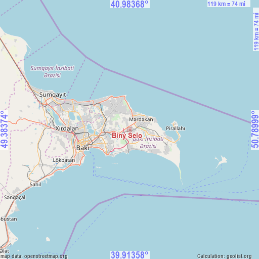
Biny Selo GPS coordinates[2]
40° 27' 2.736" North, 50° 5' 12.696" East
| Map corner | latitude | longitude |
|---|---|---|
| Upper-left | 40.98368°, | 49.38374° |
| Center: | 40.45076°, | 50.08686° |
| Lower-right: | 39.91358°, | 50.78999° |
| Map W x H: | 119×119 km | = 73.9×73.9mi |
| max Lat: | 41.75259° ⇑47.6% North |
| Biny Selo: | 40.45076° |
| min Lat: | ⇓52.4% South 38.45598° |
| min Long | Biny Selo | max Long |
| 44.84846° | 50.08686° | 50.84003° |
| W 95.7%⇐ | ⇒4.3% E |
Elevation
Elevation of Biny Selo is 1 m = 3 ft, and this is 382 m = 1253 ft below average elevation for this country.
| Max E: |
2211 m = 7254 ft | 83.2% |
| Avg. | 383 m = 1257 ft | |
| Biny Selo | 1 m = 3 ft | |
Min E: |
-26 m = -85 ft | 16.8% |
See also: Azerbaijan elevation on elevation.city.
Geographical zone
Biny Selo is located in North temperate zone (between Tropic of Cancer and the Arctic Circle). Distance of this Northern Tropic circle is 1891.8 km =1175.5 mi to South.| Distance of | km | miles | from Biny Selo |
|---|---|---|---|
| North Pole | 5509.4 | 3423.4 | to North |
| Arctic Circle | 2903.5 | 1804.2 | to North |
| Tropic Cancer | 1891.8 | 1175.5 | to South |
| Equator | 4497.7 | 2794.7 | to South |


Nearby cities:
15 places around Biny Selo: (largest is in red/bold)
• Amirdzhan
9.1 km =5.7 mi,  252°
252°
• Bakıxanov
10.7 km =6.6 mi, 250°
• Balakhani
14.3 km =8.9 mi,  275°
275°
• Bilajer
13.2 km =8.2 mi,  342°
342°
• Buzovna
7.9 km =4.9 mi,  17°
17°
• Hövsan
8.5 km =5.3 mi,  180°
180°
• Mardakan
6.6 km =4.1 mi,  46°
46°
• Maştağa
11.1 km =6.9 mi,  322°
322°
• Nardaran
13.6 km =8.5 mi,  329°
329°
• Qala
6.9 km =4.3 mi,  97°
97°
• Qaraçuxur
11.3 km =7 mi,  237°
237°
• Ramana
9 km =5.6 mi,  263°
263°
• Sabunçu
11.8 km =7.3 mi,  265°
265°
• Yeni Suraxanı
4.9 km =3 mi, 242°
• Zabrat
12.6 km =7.8 mi, 283°
Sources, notices
• [Note1] Compared only with cities in Azerbaijan existing in our database
• [Src1] Map data: © OpenStreetMap contributors (CC-BY-SA)
• [Src2] Other city data from geonames.org with taken over terms of usage.
• [Src3] Geographical zone / Annual Mean Temperature by Robert A. Rohde @ Wikipedia
