Maştağa geodata
Maştağa (Baki) is a populated place; located in Azerbaijan in Asia/Baku (GMT+4) time zone. With population of 40,092 people, there are 14 cities with bigger population in this country. Compared to other cities in Azerbaijan, 60.5% of cities are located further ↓South; 93.5% of cities are located further ←West and 73% of cities have higher elevation than Maştağa. Note1


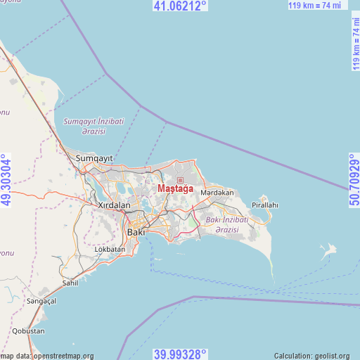
Maştağa GPS coordinates[2]
40° 31' 47.388" North, 50° 0' 22.176" East
| Map corner | latitude | longitude |
|---|---|---|
| Upper-left | 41.06212°, | 49.30304° |
| Center: | 40.52983°, | 50.00616° |
| Lower-right: | 39.99328°, | 50.70929° |
| Map W x H: | 118.8×118.8 km | = 73.8×73.8mi |
| max Lat: | 41.75259° ⇑39.5% North |
| Maştağa: | 40.52983° |
| min Lat: | ⇓60.5% South 38.45598° |
| min Long | Maştağa | max Long |
| 44.84846° | 50.00616° | 50.84003° |
| W 93.5%⇐ | ⇒6.5% E |
Elevation
Elevation of Maştağa is 19 m = 62 ft, and this is 364 m = 1194 ft below average elevation for this country.
| Max E: |
2211 m = 7254 ft | 73% |
| Avg. | 383 m = 1257 ft | |
| Maştağa | 19 m = 62 ft | |
Min E: |
-26 m = -85 ft | 27% |
See also: Maştağa elevation on elevation.city.
Geographical zone
Maştağa is located in North temperate zone (between Tropic of Cancer and the Arctic Circle). Distance of this Northern Tropic circle is 1900.6 km =1181 mi to South.| Distance of | km | miles | from Maştağa |
|---|---|---|---|
| North Pole | 5500.6 | 3417.9 | to North |
| Arctic Circle | 2894.7 | 1798.7 | to North |
| Tropic Cancer | 1900.6 | 1181 | to South |
| Equator | 4506.5 | 2800.2 | to South |


Nearby cities:
15 places around Maştağa: (largest is in red/bold)
• Amirdzhan
11.7 km =7.3 mi,  189°
189°
• Bakıxanov
12.8 km =8 mi,  195°
195°
• Balakhani
10.4 km =6.5 mi,  224°
224°
• Bilajer
4.8 km =3 mi,  36°
36°
• Biny Selo
11.1 km =6.9 mi,  142°
142°
• Buzovna
9.2 km =5.7 mi,  97°
97°
• Digah
11.9 km =7.4 mi,  249°
249°
• Mardakan
12.3 km =7.6 mi,  110°
110°
• Nardaran
2.9 km =1.8 mi,  359°
359°
• Qala
16.7 km =10.4 mi,  125°
125°
• Qaraçuxur
15.1 km =9.4 mi, 190°
• Ramana
10 km =6.2 mi, 192°
• Sabunçu
10.9 km =6.8 mi,  206°
206°
• Yeni Suraxanı
11.4 km =7.1 mi,  167°
167°
• Zabrat
8 km =5 mi, 223°
Sources, notices
• [Note1] Compared only with cities in Azerbaijan existing in our database
• [Src1] Map data: © OpenStreetMap contributors (CC-BY-SA)
• [Src2] Other city data from geonames.org with taken over terms of usage.
• [Src3] Geographical zone / Annual Mean Temperature by Robert A. Rohde @ Wikipedia
