Janja geodata
Janja (Srpska) is a populated place; located in Bosnia and Herzegovina in Europe/Sarajevo (GMT+2) time zone. With population of 5,544 people, there are 104 cities with bigger population in this country. Compared to other cities in Bosnia and Herzegovina, 65.7% of cities are located further ↓South; 97% of cities are located further ←West and 87.2% of cities have higher elevation than Janja. Note1


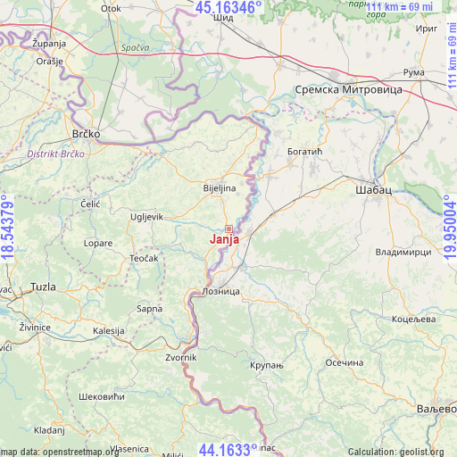
Janja GPS coordinates[2]
44° 39' 55.944" North, 19° 14' 48.876" East
| Map corner | latitude | longitude |
|---|---|---|
| Upper-left | 45.16346°, | 18.54379° |
| Center: | 44.66554°, | 19.24691° |
| Lower-right: | 44.1633°, | 19.95004° |
| Map W x H: | 111.2×111.2 km | = 69.1×69.1mi |
| max Lat: | 45.21956° ⇑34.3% North |
| Janja: | 44.66554° |
| min Lat: | ⇓65.7% South 42.71197° |
| min Long | Janja | max Long |
| 15.77806° | 19.24691° | 19.36719° |
| W 97%⇐ | ⇒3% E |
Elevation
Elevation of Janja is 105 m = 344 ft, and this is 254.5 m = 835 ft below average elevation for this country.
| Max E: |
1175 m = 3855 ft | 87.2% |
| Avg. | 359.5 m = 1179 ft | |
| Janja | 105 m = 344 ft | |
Min E: |
17 m = 56 ft | 12.8% |
See also: Bosnia and Herzegovina elevation on elevation.city.
Geographical zone
Janja is located in North temperate zone (between Tropic of Cancer and the Arctic Circle). Distance of this Northern Tropic circle is 2360.4 km =1466.7 mi to South.| Distance of | km | miles | from Janja |
|---|---|---|---|
| North Pole | 5040.7 | 3132.1 | to North |
| Arctic Circle | 2434.8 | 1512.9 | to North |
| Tropic Cancer | 2360.4 | 1466.7 | to South |
| Equator | 4966.3 | 3085.9 | to South |


Nearby cities:
15 places around Janja: (largest is in red/bold)
• Balatun
23.2 km =14.4 mi,  18°
18°
• Bijeljina
10.7 km =6.6 mi,  346°
346°
• Brodac-Gornji
22.1 km =13.7 mi,  3°
3°
• Dvorovi
15.8 km =9.8 mi, 3°
• Kojčinovac
2.7 km =1.7 mi, 347°
• Lopare
32.1 km =19.9 mi,  263°
263°
• Ostojićevo
21.5 km =13.4 mi,  357°
357°
• Petkovci
25.8 km =16 mi,  211°
211°
• Popovi
11.5 km =7.1 mi, 15°
• Priboj
25.9 km =16.1 mi,  254°
254°
• Sapna
26.7 km =16.6 mi,  227°
227°
• Teočak
22.3 km =13.9 mi, 251°
• Ugljevik
17.9 km =11.1 mi,  269°
269°
• Velika Obarska
16.9 km =10.5 mi,  336°
336°
• Zvornik
33.1 km =20.6 mi,  200°
200°
Sources, notices
• [Note1] Compared only with cities in Bosnia and Herzegovina existing in our database
• [Src1] Map data: © OpenStreetMap contributors (CC-BY-SA)
• [Src2] Other city data from geonames.org with taken over terms of usage.
• [Src3] Geographical zone / Annual Mean Temperature by Robert A. Rohde @ Wikipedia
