Azimpur geodata
Azimpur (Dhaka) is a populated place; located in Bangladesh in Asia/Dhaka (GMT+6) time zone. With population of 96,641 people, there are 37 cities with bigger population in this country. Compared to other cities in Bangladesh, 53.8% of cities are located further ↑North; 62.4% of cities are located further ←West and 56.4% of cities have higher elevation than Azimpur. Note1


Azimpur GPS coordinates[2]
23° 43' 47.28" North, 90° 23' 7.44" East
| Map corner | latitude | longitude |
|---|---|---|
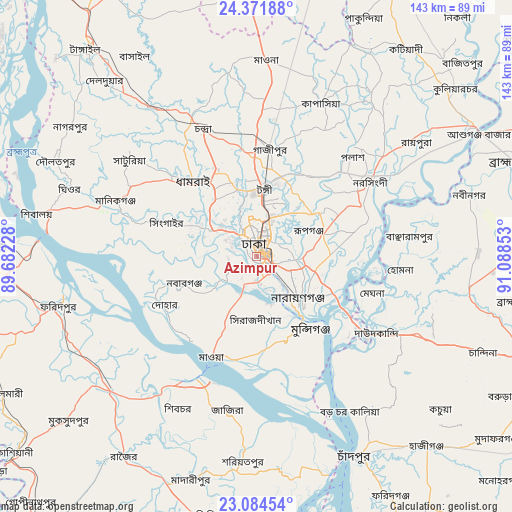
| Upper-left | 24.37188°, | 89.68228° |
| Center: | 23.7298°, | 90.3854° |
| Lower-right: | 23.08454°, | 91.08853° |
| Map W x H: | 143.1×143.1 km | = 88.9×88.9mi |
| max Lat: | 26.33338° ⇑53.8% North |
| Azimpur: | 23.7298° |
| min Lat: | ⇓46.2% South 20.85829° |
| min Long | Azimpur | max Long |
| 88.15638° | 90.3854° | 92.29773° |
| W 62.4%⇐ | ⇒37.6% E |
Elevation
Elevation of Azimpur is 14 m = 46 ft, and this is 3.9 m = 13 ft below average elevation for this country.
| Max E: |
79 m = 259 ft | 56.4% |
| Avg. | 17.9 m = 59 ft | |
| Azimpur | 14 m = 46 ft | |
Min E: |
2 m = 7 ft | 43.6% |
See also: Azimpur elevation on elevation.city.
Geographical zone
Azimpur is located in North temperate zone (between Tropic of Cancer and the Arctic Circle). Distance of this Northern Tropic circle is 32.6 km =20.3 mi to South.| Distance of | km | miles | from Azimpur |
|---|---|---|---|
| North Pole | 7368.6 | 4578.6 | to North |
| Arctic Circle | 4762.7 | 2959.4 | to North |
| Tropic Cancer | 32.6 | 20.3 | to South |
| Equator | 2638.5 | 1639.5 | to South |


Nearby cities:
15 places around Azimpur: (largest is in red/bold)
• Char Bhadrāsan
49.5 km =30.8 mi,  199°
199°
• Char Golora
28.7 km =17.8 mi,  290°
290°
• Dhaka
3.1 km =1.9 mi,  133°
133°
• Dohār
29 km =18 mi,  238°
238°
• Joymontop
23.4 km =14.5 mi, 286°
• Khanbaniara
21.3 km =13.2 mi, 285°
• Narsingdi
40 km =24.9 mi,  57°
57°
• Nārāyanganj
17.6 km =10.9 mi,  137°
137°
• Paltan
3 km =1.9 mi,  76°
76°
• Parvez Ali
28.8 km =17.9 mi, 289°
• Parvez Ali Hossain
23.3 km =14.5 mi, 285°
• Ramnagar
21.9 km =13.6 mi,  283°
283°
• Sayani
23 km =14.3 mi, 287°
• Sonārgaon
25.2 km =15.7 mi,  110°
110°
• Tungi
18.1 km =11.2 mi,  5°
5°
Sources, notices
• [Note1] Compared only with cities in Bangladesh existing in our database
• [Src1] Map data: © OpenStreetMap contributors (CC-BY-SA)
• [Src2] Other city data from geonames.org with taken over terms of usage.
• [Src3] Geographical zone / Annual Mean Temperature by Robert A. Rohde @ Wikipedia
