Sayani geodata
Sayani (Dhaka) is a farm village; located in Bangladesh in Asia/Dhaka (GMT+6) time zone. With population of 1,500 people, there are 113 cities with bigger population in this country. Compared to other cities in Bangladesh, 51.3% of cities are located further ↓South; 53.8% of cities are located further ←West and 65% of cities have higher elevation than Sayani. Note1


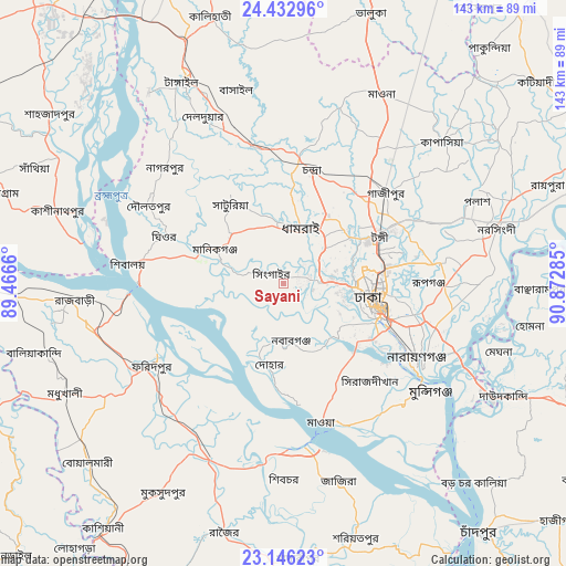
Sayani GPS coordinates[2]
23° 47' 28.284" North, 90° 10' 10.992" East
| Map corner | latitude | longitude |
|---|---|---|
| Upper-left | 24.43296°, | 89.4666° |
| Center: | 23.79119°, | 90.16972° |
| Lower-right: | 23.14623°, | 90.87285° |
| Map W x H: | 143.1×143.1 km | = 88.9×88.9mi |
| max Lat: | 26.33338° ⇑48.7% North |
| Sayani: | 23.79119° |
| min Lat: | ⇓51.3% South 20.85829° |
| min Long | Sayani | max Long |
| 88.15638° | 90.16972° | 92.29773° |
| W 53.8%⇐ | ⇒46.2% E |
Elevation
Elevation of Sayani is 13 m = 43 ft, and this is 4.9 m = 16 ft below average elevation for this country.
| Max E: |
79 m = 259 ft | 65% |
| Avg. | 17.9 m = 59 ft | |
| Sayani | 13 m = 43 ft | |
Min E: |
2 m = 7 ft | 35% |
See also: Bangladesh elevation on elevation.city.
Geographical zone
Sayani is located in North temperate zone (between Tropic of Cancer and the Arctic Circle). Distance of this Northern Tropic circle is 39.4 km =24.5 mi to South.| Distance of | km | miles | from Sayani |
|---|---|---|---|
| North Pole | 7361.7 | 4574.3 | to North |
| Arctic Circle | 4755.8 | 2955.1 | to North |
| Tropic Cancer | 39.4 | 24.5 | to South |
| Equator | 2645.3 | 1643.7 | to South |


Nearby cities:
15 places around Sayani: (largest is in red/bold)
• Azimpur
23 km =14.3 mi,  107°
107°
• Char Golora
5.9 km =3.7 mi,  303°
303°
• Dhaka
25.8 km =16 mi, 110°
• Dohār
22.2 km =13.8 mi,  187°
187°
• Farīdpur
39.3 km =24.4 mi,  238°
238°
• Joymontop
0.6 km =0.4 mi,  234°
234°
• Khanbaniara
1.7 km =1.1 mi,  124°
124°
• Mirzāpur
35.4 km =22 mi,  348°
348°
• Nāgarpur
42 km =26.1 mi,  314°
314°
• Nārāyanganj
39.3 km =24.4 mi, 120°
• Paltan
25.6 km =15.9 mi,  103°
103°
• Parvez Ali
5.9 km =3.7 mi, 299°
• Parvez Ali Hossain
0.6 km =0.4 mi, 230°
• Ramnagar
1.7 km =1.1 mi,  157°
157°
• Tungi
26.2 km =16.3 mi,  64°
64°
Sources, notices
• [Note1] Compared only with cities in Bangladesh existing in our database
• [Src1] Map data: © OpenStreetMap contributors (CC-BY-SA)
• [Src2] Other city data from geonames.org with taken over terms of usage.
• [Src3] Geographical zone / Annual Mean Temperature by Robert A. Rohde @ Wikipedia
