Char Bhadrāsan geodata
Char Bhadrāsan (Dhaka) is a populated place; located in Bangladesh in Asia/Dhaka (GMT+6) time zone. With population of 34,423 people, there are 92 cities with bigger population in this country. Compared to other cities in Bangladesh, 62.4% of cities are located further ↑North; 58.1% of cities are located further ←West and 76.1% of cities have higher elevation than Char Bhadrāsan. Note1


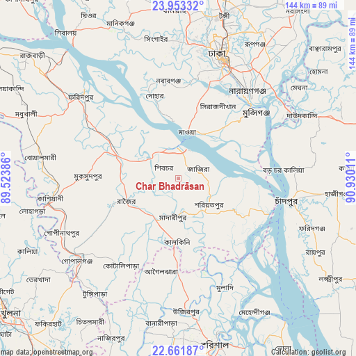
Char Bhadrāsan GPS coordinates[2]
23° 18' 32.976" North, 90° 13' 37.128" East
| Map corner | latitude | longitude |
|---|---|---|
| Upper-left | 23.95332°, | 89.52386° |
| Center: | 23.30916°, | 90.22698° |
| Lower-right: | 22.66187°, | 90.93011° |
| Map W x H: | 143.6×143.6 km | = 89.2×89.2mi |
| max Lat: | 26.33338° ⇑62.4% North |
| Char Bhadrāsan: | 23.30916° |
| min Lat: | ⇓37.6% South 20.85829° |
| min Long | Char Bhadrāsan | max Long |
| 88.15638° | 90.22698° | 92.29773° |
| W 58.1%⇐ | ⇒41.9% E |
Elevation
Elevation of Char Bhadrāsan is 11 m = 36 ft, and this is 6.9 m = 23 ft below average elevation for this country.
| Max E: |
79 m = 259 ft | 76.1% |
| Avg. | 17.9 m = 59 ft | |
| Char Bhadrāsan | 11 m = 36 ft | |
Min E: |
2 m = 7 ft | 23.9% |
See also: Bangladesh elevation on elevation.city.
Geographical zone
Char Bhadrāsan is located in North Torrid zone (between Equator and Tropic of Cancer). Distance of this Northern Tropic circle is 14.2 km =8.8 mi to North.| Distance of | km | miles | from Char Bhadrāsan |
|---|---|---|---|
| North Pole | 7415.3 | 4607.7 | to North |
| Arctic Circle | 4809.4 | 2988.4 | to North |
| Tropic Cancer | 14.2 | 8.8 | to North |
| Equator | 2591.7 | 1610.4 | to South |


Nearby cities:
15 places around Char Bhadrāsan: (largest is in red/bold)
• Azimpur
49.5 km =30.8 mi,  19°
19°
• Dhaka
48.3 km =30 mi, 22°
• Dohār
32.7 km =20.3 mi,  344°
344°
• Farīdpur
51.4 km =31.9 mi,  309°
309°
• Gaurnadi
37.3 km =23.2 mi,  180°
180°
• Joymontop
53.6 km =33.3 mi,  353°
353°
• Khanbaniara
52.8 km =32.8 mi,  355°
355°
• Mādārīpur
15.5 km =9.6 mi,  186°
186°
• Nārāyanganj
44 km =27.3 mi,  39°
39°
• Paltan
51.2 km =31.8 mi, 21°
• Parvez Ali Hossain
53.6 km =33.3 mi, 353°
• Pālang
16.2 km =10.1 mi,  128°
128°
• Ramnagar
52.3 km =32.5 mi, 354°
• Sayani
53.9 km =33.5 mi, 353°
• Sonārgaon
54.9 km =34.1 mi,  46°
46°
Sources, notices
• [Note1] Compared only with cities in Bangladesh existing in our database
• [Src1] Map data: © OpenStreetMap contributors (CC-BY-SA)
• [Src2] Other city data from geonames.org with taken over terms of usage.
• [Src3] Geographical zone / Annual Mean Temperature by Robert A. Rohde @ Wikipedia
