Dohār geodata
Dohār (Dhaka) is a populated place; located in Bangladesh in Asia/Dhaka (GMT+6) time zone. With population of 45,543 people, there are 70 cities with bigger population in this country. Compared to other cities in Bangladesh, 59% of cities are located further ↑North; 50.4% of cities are located further ←West and 56.4% of cities have higher elevation than Dohār. Note1


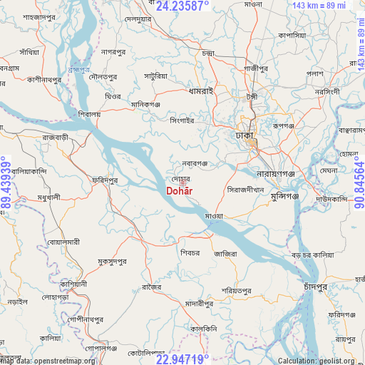
Dohār GPS coordinates[2]
23° 35' 35.196" North, 90° 8' 33.036" East
| Map corner | latitude | longitude |
|---|---|---|
| Upper-left | 24.23587°, | 89.43939° |
| Center: | 23.59311°, | 90.14251° |
| Lower-right: | 22.94719°, | 90.84564° |
| Map W x H: | 143.3×143.3 km | = 89×89mi |
| max Lat: | 26.33338° ⇑59% North |
| Dohār: | 23.59311° |
| min Lat: | ⇓41% South 20.85829° |
| min Long | Dohār | max Long |
| 88.15638° | 90.14251° | 92.29773° |
| W 50.4%⇐ | ⇒49.6% E |
Elevation
Elevation of Dohār is 14 m = 46 ft, and this is 3.9 m = 13 ft below average elevation for this country.
| Max E: |
79 m = 259 ft | 56.4% |
| Avg. | 17.9 m = 59 ft | |
| Dohār | 14 m = 46 ft | |
Min E: |
2 m = 7 ft | 43.6% |
See also: Dohār elevation on elevation.city.
Geographical zone
Dohār is located in North temperate zone (between Tropic of Cancer and the Arctic Circle). Distance of this Northern Tropic circle is 17.4 km =10.8 mi to South.| Distance of | km | miles | from Dohār |
|---|---|---|---|
| North Pole | 7383.8 | 4588.1 | to North |
| Arctic Circle | 4777.9 | 2968.8 | to North |
| Tropic Cancer | 17.4 | 10.8 | to South |
| Equator | 2623.3 | 1630 | to South |


Nearby cities:
15 places around Dohār: (largest is in red/bold)
• Azimpur
29 km =18 mi,  58°
58°
• Char Bhadrāsan
32.7 km =20.3 mi,  164°
164°
• Char Golora
25.4 km =15.8 mi,  355°
355°
• Dhaka
30 km =18.6 mi, 64°
• Farīdpur
30.8 km =19.1 mi,  272°
272°
• Joymontop
21.8 km =13.5 mi,  5°
5°
• Khanbaniara
21.4 km =13.3 mi, 11°
• Nārāyanganj
36.8 km =22.9 mi,  86°
86°
• Paltan
31.9 km =19.8 mi, 60°
• Parvez Ali
25.1 km =15.6 mi,  354°
354°
• Parvez Ali Hossain
21.7 km =13.5 mi, 6°
• Pālang
46.8 km =29.1 mi,  152°
152°
• Ramnagar
20.8 km =12.9 mi, 9°
• Sayani
22.2 km =13.8 mi, 7°
• Tungi
42.4 km =26.3 mi,  38°
38°
Sources, notices
• [Note1] Compared only with cities in Bangladesh existing in our database
• [Src1] Map data: © OpenStreetMap contributors (CC-BY-SA)
• [Src2] Other city data from geonames.org with taken over terms of usage.
• [Src3] Geographical zone / Annual Mean Temperature by Robert A. Rohde @ Wikipedia
