Tāngāil geodata
Tāngāil (Dhaka) is a populated place; located in Bangladesh in Asia/Dhaka (GMT+6) time zone. With population of 180,144 people, there are 24 cities with bigger population in this country. Compared to other cities in Bangladesh, 65.8% of cities are located further ↓South; 57.3% of cities are located further →East and 62.4% of cities have lower elevation than Tāngāil. Note1
Administrative division(s):
- Level 1: Dhaka
- Level 2: Tangail
- Level 3: Tangail Sadar
- Level 4: Paurashava


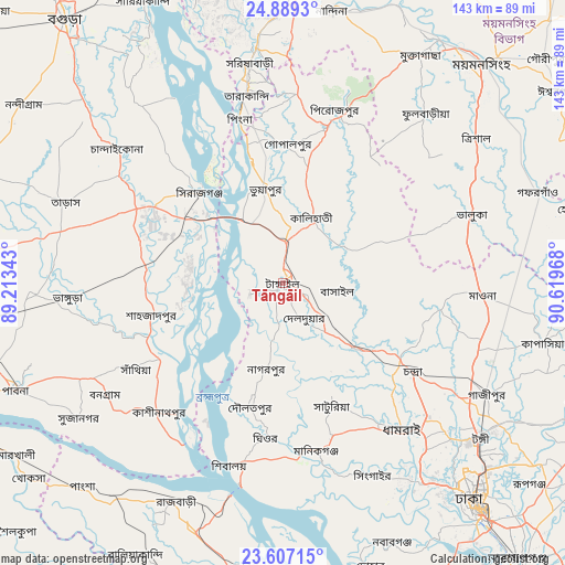
Tāngāil GPS coordinates[2]
24° 14' 59.424" North, 89° 54' 59.58" East
| Map corner | latitude | longitude |
|---|---|---|
| Upper-left | 24.8893°, | 89.21343° |
| Center: | 24.24984°, | 89.91655° |
| Lower-right: | 23.60715°, | 90.61968° |
| Map W x H: | 142.6×142.6 km | = 88.6×88.6mi |
| max Lat: | 26.33338° ⇑34.2% North |
| Tāngāil: | 24.24984° |
| min Lat: | ⇓65.8% South 20.85829° |
| min Long | Tāngāil | max Long |
| 88.15638° | 89.91655° | 92.29773° |
| W 42.7%⇐ | ⇒57.3% E |
Elevation
Elevation of Tāngāil is 17 m = 56 ft, and this is 0.9 m = 3 ft below average elevation for this country.
| Max E: |
79 m = 259 ft | 37.6% |
| Avg. | 17.9 m = 59 ft | |
| Tāngāil | 17 m = 56 ft | |
Min E: |
2 m = 7 ft | 62.4% |
See also: Tāngāil elevation on elevation.city.
Geographical zone
Tāngāil is located in North temperate zone (between Tropic of Cancer and the Arctic Circle). Distance of this Northern Tropic circle is 90.4 km =56.2 mi to South.| Distance of | km | miles | from Tāngāil |
|---|---|---|---|
| North Pole | 7310.7 | 4542.7 | to North |
| Arctic Circle | 4704.8 | 2923.4 | to North |
| Tropic Cancer | 90.4 | 56.2 | to South |
| Equator | 2696.3 | 1675.4 | to South |


Nearby cities:
15 places around Tāngāil: (largest is in red/bold)
• Bera
34.6 km =21.5 mi,  236°
236°
• Char Golora
52.1 km =32.4 mi,  156°
156°
• Joymontop
57.2 km =35.5 mi,  153°
153°
• Khanbaniara
58.7 km =36.5 mi, 152°
• Mirzāpur
24.6 km =15.3 mi,  131°
131°
• Nāgarpur
21.7 km =13.5 mi,  190°
190°
• Parvez Ali
52.3 km =32.5 mi, 156°
• Parvez Ali Hossain
57.3 km =35.6 mi, 153°
• Ramnagar
58.8 km =36.5 mi, 153°
• Sakhipur
26.8 km =16.7 mi,  73°
73°
• Sarishābāri
56.4 km =35 mi,  351°
351°
• Sayani
57.1 km =35.5 mi, 153°
• Shāhzādpur
33.2 km =20.6 mi,  255°
255°
• Sirajganj
31.3 km =19.4 mi,  317°
317°
• Tungi
63.4 km =39.4 mi, 128°
Sources, notices
• [Note1] Compared only with cities in Bangladesh existing in our database
• [Src1] Map data: © OpenStreetMap contributors (CC-BY-SA)
• [Src2] Other city data from geonames.org with taken over terms of usage.
• [Src3] Geographical zone / Annual Mean Temperature by Robert A. Rohde @ Wikipedia
