Buggenhout geodata
Buggenhout (Flanders) is a populated place; located in Belgium in Europe/Brussels (GMT+2) time zone. With population of 13,510 people, there are 217 cities with bigger population in this country. Compared to other cities in Belgium, 72.6% of cities are located further ↓South; 68.1% of cities are located further →East and 88.4% of cities have higher elevation than Buggenhout. Note1
Administrative division(s):
- Level 1: Flanders
- Level 2: Provincie Oost-Vlaanderen
- Level 3: Arrondissement Dendermonde
- Level 4: Buggenhout


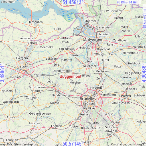
Buggenhout GPS coordinates[2]
51° 0' 57.24" North, 4° 12' 6.228" East
| Map corner | latitude | longitude |
|---|---|---|
| Upper-left | 51.45613°, | 3.49861° |
| Center: | 51.0159°, | 4.20173° |
| Lower-right: | 50.57145°, | 4.90486° |
| Map W x H: | 98.4×98.4 km | = 61.1×61.1mi |
| max Lat: | 51.46791° ⇑27.4% North |
| Buggenhout: | 51.0159° |
| min Lat: | ⇓72.6% South 49.53771° |
| min Long | Buggenhout | max Long |
| 2.59368° | 4.20173° | 6.25749° |
| W 31.9%⇐ | ⇒68.1% E |
Elevation
Elevation of Buggenhout is 9 m = 30 ft, and this is 90.5 m = 297 ft below average elevation for this country.
| Max E: |
582 m = 1909 ft | 88.4% |
| Avg. | 99.5 m = 326 ft | |
| Buggenhout | 9 m = 30 ft | |
Min E: |
1 m = 3 ft | 11.6% |
See also: Belgium elevation on elevation.city.
Geographical zone
Buggenhout is located in North temperate zone (between Tropic of Cancer and the Arctic Circle). Distance of this North polar circle is 1728.7 km =1074.2 mi to North.| Distance of | km | miles | from Buggenhout |
|---|---|---|---|
| North Pole | 4334.6 | 2693.4 | to North |
| Arctic Circle | 1728.7 | 1074.2 | to North |
| Tropic Cancer | 3066.5 | 1905.4 | to South |
| Equator | 5672.4 | 3524.7 | to South |


Nearby cities:
15 places around Buggenhout: (largest is in red/bold)
• Asse
11.8 km =7.3 mi,  181°
181°
• Bornem
9.5 km =5.9 mi,  17°
17°
• Dendermonde
7.2 km =4.5 mi,  281°
281°
• Hamme
10.2 km =6.3 mi,  333°
333°
• Kapelle-op-den-Bos
11.3 km =7 mi,  93°
93°
• Lebbeke
4.9 km =3 mi,  255°
255°
• Londerzeel
7.2 km =4.5 mi,  99°
99°
• Meise
12.2 km =7.6 mi,  134°
134°
• Merchtem
7.5 km =4.7 mi,  163°
163°
• Opwijk
5.5 km =3.4 mi,  192°
192°
• Puurs
8.9 km =5.5 mi,  43°
43°
• Sint-Amands
4.5 km =2.8 mi,  6°
6°
• Temse
12.5 km =7.8 mi,  3°
3°
• Willebroek
12.1 km =7.5 mi,  65°
65°
• Zele
12.6 km =7.8 mi,  296°
296°
Sources, notices
• [Note1] Compared only with cities in Belgium existing in our database
• [Src1] Map data: © OpenStreetMap contributors (CC-BY-SA)
• [Src2] Other city data from geonames.org with taken over terms of usage.
• [Src3] Geographical zone / Annual Mean Temperature by Robert A. Rohde @ Wikipedia
