Theux geodata
Theux (Wallonia) is a populated place; located in Belgium in Europe/Brussels (GMT+2) time zone. With population of 11,587 people, there are 259 cities with bigger population in this country. Compared to other cities in Belgium, 74.7% of cities are located further ↑North; 95.3% of cities are located further ←West and 78.7% of cities have lower elevation than Theux. Note1
Administrative division(s):
- Level 1: Wallonia
- Level 2: Province de Liège
- Level 3: Arrondissement de Verviers
- Level 4: Theux


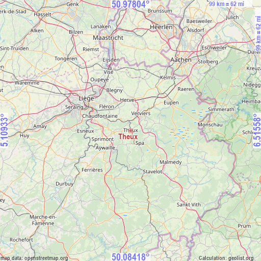
Theux GPS coordinates[2]
50° 31' 59.628" North, 5° 48' 44.82" East
| Map corner | latitude | longitude |
|---|---|---|
| Upper-left | 50.97804°, | 5.10933° |
| Center: | 50.53323°, | 5.81245° |
| Lower-right: | 50.08418°, | 6.51558° |
| Map W x H: | 99.4×99.4 km | = 61.8×61.8mi |
| max Lat: | 51.46791° ⇑74.7% North |
| Theux: | 50.53323° |
| min Lat: | ⇓25.3% South 49.53771° |
| min Long | Theux | max Long |
| 2.59368° | 5.81245° | 6.25749° |
| W 95.3%⇐ | ⇒4.7% E |
Elevation
Elevation of Theux is 168 m = 551 ft, and this is 68.5 m = 225 ft above average elevation for this country.
| Max E: |
582 m = 1909 ft | 21.3% |
| Theux | 168 m 551 ft | |
| Avg. | 99.5 m = 326 ft | |
Min E: |
1 m = 3 ft | 78.7% |
See also: Belgium elevation on elevation.city.
Geographical zone
Theux is located in North temperate zone (between Tropic of Cancer and the Arctic Circle). Distance of this North polar circle is 1782.4 km =1107.5 mi to North.| Distance of | km | miles | from Theux |
|---|---|---|---|
| North Pole | 4388.3 | 2726.8 | to North |
| Arctic Circle | 1782.4 | 1107.5 | to North |
| Tropic Cancer | 3012.8 | 1872.1 | to South |
| Equator | 5618.8 | 3491.4 | to South |


Nearby cities:
15 places around Theux: (largest is in red/bold)
• Aywaille
11.6 km =7.2 mi,  235°
235°
• Chaudfontaine
13.8 km =8.6 mi,  293°
293°
• Dison
9 km =5.6 mi,  18°
18°
• Fléron
13 km =8.1 mi,  314°
314°
• Herve
12 km =7.5 mi,  353°
353°
• Jalhay
11.3 km =7 mi,  75°
75°
• Limbourg
12.6 km =7.8 mi,  45°
45°
• Olne
7.8 km =4.8 mi,  323°
323°
• Pepinster
4.5 km =2.8 mi, 353°
• Soumagne
10.1 km =6.3 mi,  332°
332°
• Spa
6.7 km =4.2 mi,  145°
145°
• Sprimont
11.1 km =6.9 mi,  256°
256°
• Stoumont
14.1 km =8.8 mi,  181°
181°
• Trooz
9.2 km =5.7 mi,  296°
296°
• Verviers
7.1 km =4.4 mi,  29°
29°
Sources, notices
• [Note1] Compared only with cities in Belgium existing in our database
• [Src1] Map data: © OpenStreetMap contributors (CC-BY-SA)
• [Src2] Other city data from geonames.org with taken over terms of usage.
• [Src3] Geographical zone / Annual Mean Temperature by Robert A. Rohde @ Wikipedia
