Verviers geodata
Verviers (Wallonia) is a populated place; located in Belgium in Europe/Brussels (GMT+2) time zone. With population of 52,824 people, there are 21 cities with bigger population in this country. Compared to other cities in Belgium, 70% of cities are located further ↑North; 96.4% of cities are located further ←West and 83.4% of cities have lower elevation than Verviers. Note1
Administrative division(s):
- Level 1: Wallonia
- Level 2: Province de Liège
- Level 3: Arrondissement de Verviers
- Level 4: Verviers


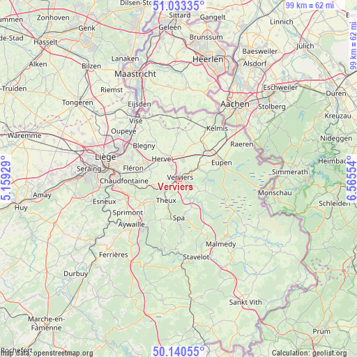
Verviers GPS coordinates[2]
50° 35' 20.652" North, 5° 51' 44.676" East
| Map corner | latitude | longitude |
|---|---|---|
| Upper-left | 51.03335°, | 5.15929° |
| Center: | 50.58907°, | 5.86241° |
| Lower-right: | 50.14055°, | 6.56554° |
| Map W x H: | 99.3×99.3 km | = 61.7×61.7mi |
| max Lat: | 51.46791° ⇑70% North |
| Verviers: | 50.58907° |
| min Lat: | ⇓30% South 49.53771° |
| min Long | Verviers | max Long |
| 2.59368° | 5.86241° | 6.25749° |
| W 96.4%⇐ | ⇒3.6% E |
Elevation
Elevation of Verviers is 201 m = 659 ft, and this is 101.5 m = 333 ft above average elevation for this country.
| Max E: |
582 m = 1909 ft | 16.6% |
| Verviers | 201 m 659 ft | |
| Avg. | 99.5 m = 326 ft | |
Min E: |
1 m = 3 ft | 83.4% |
See also: Verviers elevation on elevation.city.
Geographical zone
Verviers is located in North temperate zone (between Tropic of Cancer and the Arctic Circle). Distance of this North polar circle is 1776.2 km =1103.7 mi to North.| Distance of | km | miles | from Verviers |
|---|---|---|---|
| North Pole | 4382.1 | 2722.9 | to North |
| Arctic Circle | 1776.2 | 1103.7 | to North |
| Tropic Cancer | 3019.1 | 1876 | to South |
| Equator | 5625 | 3495.2 | to South |


Nearby cities:
15 places around Verviers: (largest is in red/bold)
• Aubel
12.5 km =7.8 mi,  358°
358°
• Baelen
9.2 km =5.7 mi,  59°
59°
• Dison
2.4 km =1.5 mi,  344°
344°
• Eupen
13 km =8.1 mi,  70°
70°
• Fléron
13.2 km =8.2 mi,  282°
282°
• Herve
7.5 km =4.7 mi,  319°
319°
• Jalhay
8.2 km =5.1 mi,  114°
114°
• Limbourg
6.1 km =3.8 mi, 65°
• Olne
8.2 km =5.1 mi,  270°
270°
• Pepinster
4.4 km =2.7 mi,  247°
247°
• Soumagne
8.6 km =5.3 mi,  288°
288°
• Spa
11.7 km =7.3 mi,  178°
178°
• Theux
7.1 km =4.4 mi,  209°
209°
• Trooz
12 km =7.5 mi,  259°
259°
• Welkenraedt
11 km =6.8 mi,  43°
43°
Sources, notices
• [Note1] Compared only with cities in Belgium existing in our database
• [Src1] Map data: © OpenStreetMap contributors (CC-BY-SA)
• [Src2] Other city data from geonames.org with taken over terms of usage.
• [Src3] Geographical zone / Annual Mean Temperature by Robert A. Rohde @ Wikipedia
