Spa geodata
Spa (Wallonia) is a populated place; located in Belgium in Europe/Brussels (GMT+2) time zone. With population of 10,756 people, there are 284 cities with bigger population in this country. Compared to other cities in Belgium, 77.6% of cities are located further ↑North; 96.6% of cities are located further ←West and 93.5% of cities have lower elevation than Spa. Note1
Administrative division(s):
- Level 1: Wallonia
- Level 2: Province de Liège
- Level 3: Arrondissement de Verviers
- Level 4: Spa


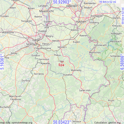
Spa GPS coordinates[2]
50° 29' 1.5" North, 5° 52' 0.264" East
| Map corner | latitude | longitude |
|---|---|---|
| Upper-left | 50.92903°, | 5.16361° |
| Center: | 50.48375°, | 5.86674° |
| Lower-right: | 50.03423°, | 6.56986° |
| Map W x H: | 99.5×99.5 km | = 61.8×61.8mi |
| max Lat: | 51.46791° ⇑77.6% North |
| Spa: | 50.48375° |
| min Lat: | ⇓22.4% South 49.53771° |
| min Long | Spa | max Long |
| 2.59368° | 5.86674° | 6.25749° |
| W 96.6%⇐ | ⇒3.4% E |
Elevation
Elevation of Spa is 312 m = 1024 ft, and this is 212.5 m = 697 ft above average elevation for this country.
| Max E: |
582 m = 1909 ft | 6.5% |
| Spa | 312 m 1024 ft | |
| Avg. | 99.5 m = 326 ft | |
Min E: |
1 m = 3 ft | 93.5% |
See also: Belgium elevation on elevation.city.
Geographical zone
Spa is located in North temperate zone (between Tropic of Cancer and the Arctic Circle). Distance of this North polar circle is 1787.9 km =1110.9 mi to North.| Distance of | km | miles | from Spa |
|---|---|---|---|
| North Pole | 4393.8 | 2730.2 | to North |
| Arctic Circle | 1787.9 | 1110.9 | to North |
| Tropic Cancer | 3007.3 | 1868.6 | to South |
| Equator | 5613.3 | 3487.9 | to South |


Nearby cities:
15 places around Spa: (largest is in red/bold)
• Aywaille
13.5 km =8.4 mi,  265°
265°
• Dison
14.1 km =8.8 mi,  356°
356°
• Jalhay
11 km =6.8 mi,  40°
40°
• Limbourg
15.2 km =9.4 mi,  20°
20°
• Malmédy
13 km =8.1 mi,  118°
118°
• Olne
14.5 km =9 mi,  324°
324°
• Pepinster
10.9 km =6.8 mi,  336°
336°
• Soumagne
16.8 km =10.4 mi,  329°
329°
• Sprimont
14.9 km =9.3 mi,  280°
280°
• Stavelot
10.9 km =6.8 mi,  155°
155°
• Stoumont
9.5 km =5.9 mi,  205°
205°
• Theux
6.7 km =4.2 mi, 325°
• Trois-Ponts
12.5 km =7.8 mi,  178°
178°
• Trooz
15.5 km =9.6 mi,  308°
308°
• Verviers
11.7 km =7.3 mi, 358°
Sources, notices
• [Note1] Compared only with cities in Belgium existing in our database
• [Src1] Map data: © OpenStreetMap contributors (CC-BY-SA)
• [Src2] Other city data from geonames.org with taken over terms of usage.
• [Src3] Geographical zone / Annual Mean Temperature by Robert A. Rohde @ Wikipedia
