Herve geodata
Herve (Wallonia) is a populated place; located in Belgium in Europe/Brussels (GMT+2) time zone. With population of 16,544 people, there are 167 cities with bigger population in this country. Compared to other cities in Belgium, 64.4% of cities are located further ↑North; 94.6% of cities are located further ←West and 92.8% of cities have lower elevation than Herve. Note1
Administrative division(s):
- Level 1: Wallonia
- Level 2: Province de Liège
- Level 3: Arrondissement de Verviers
- Level 4: Herve


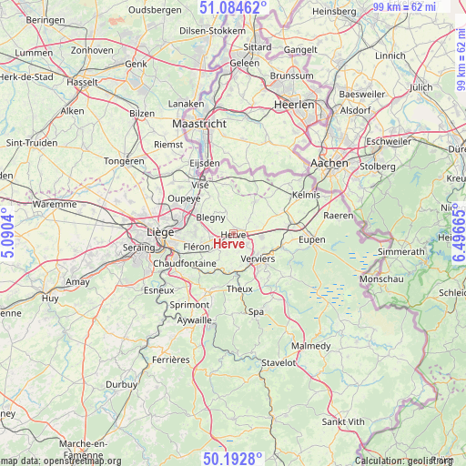
Herve GPS coordinates[2]
50° 38' 26.988" North, 5° 47' 36.708" East
| Map corner | latitude | longitude |
|---|---|---|
| Upper-left | 51.08462°, | 5.0904° |
| Center: | 50.64083°, | 5.79353° |
| Lower-right: | 50.1928°, | 6.49665° |
| Map W x H: | 99.2×99.2 km | = 61.6×61.6mi |
| max Lat: | 51.46791° ⇑64.4% North |
| Herve: | 50.64083° |
| min Lat: | ⇓35.6% South 49.53771° |
| min Long | Herve | max Long |
| 2.59368° | 5.79353° | 6.25749° |
| W 94.6%⇐ | ⇒5.4% E |
Elevation
Elevation of Herve is 300 m = 984 ft, and this is 200.5 m = 658 ft above average elevation for this country.
| Max E: |
582 m = 1909 ft | 7.2% |
| Herve | 300 m 984 ft | |
| Avg. | 99.5 m = 326 ft | |
Min E: |
1 m = 3 ft | 92.8% |
See also: Belgium elevation on elevation.city.
Geographical zone
Herve is located in North temperate zone (between Tropic of Cancer and the Arctic Circle). Distance of this North polar circle is 1770.4 km =1100.1 mi to North.| Distance of | km | miles | from Herve |
|---|---|---|---|
| North Pole | 4376.3 | 2719.3 | to North |
| Arctic Circle | 1770.4 | 1100.1 | to North |
| Tropic Cancer | 3024.8 | 1879.5 | to South |
| Equator | 5630.7 | 3498.8 | to South |


Nearby cities:
15 places around Herve: (largest is in red/bold)
• Aubel
8.2 km =5.1 mi,  33°
33°
• Beyne-Heusay
9.3 km =5.8 mi,  257°
257°
• Blégny
6 km =3.7 mi,  306°
306°
• Dalhem
9.3 km =5.8 mi,  330°
330°
• Dison
5.4 km =3.4 mi,  129°
129°
• Fléron
8.5 km =5.3 mi,  250°
250°
• Herstal
12.3 km =7.6 mi,  282°
282°
• Limbourg
10.9 km =6.8 mi,  106°
106°
• Olne
6.6 km =4.1 mi,  210°
210°
• Pepinster
7.5 km =4.7 mi,  173°
173°
• Sint-Pieters-Voeren
11.1 km =6.9 mi,  10°
10°
• Soumagne
4.5 km =2.8 mi,  227°
227°
• Theux
12 km =7.5 mi, 173°
• Trooz
10.5 km =6.5 mi,  221°
221°
• Verviers
7.5 km =4.7 mi,  139°
139°
Sources, notices
• [Note1] Compared only with cities in Belgium existing in our database
• [Src1] Map data: © OpenStreetMap contributors (CC-BY-SA)
• [Src2] Other city data from geonames.org with taken over terms of usage.
• [Src3] Geographical zone / Annual Mean Temperature by Robert A. Rohde @ Wikipedia
