Malmédy geodata
Malmédy (Wallonia) is a populated place; located in Belgium in Europe/Brussels (GMT+2) time zone. With population of 11,514 people, there are 263 cities with bigger population in this country. Compared to other cities in Belgium, 81.9% of cities are located further ↑North; 98.7% of cities are located further ←West and 94.9% of cities have lower elevation than Malmédy. Note1
Administrative division(s):
- Level 1: Wallonia
- Level 2: Province de Liège
- Level 3: Arrondissement de Verviers
- Level 4: Malmédy


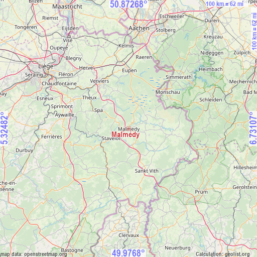
Malmédy GPS coordinates[2]
50° 25' 36.696" North, 6° 1' 40.584" East
| Map corner | latitude | longitude |
|---|---|---|
| Upper-left | 50.87268°, | 5.32482° |
| Center: | 50.42686°, | 6.02794° |
| Lower-right: | 49.9768°, | 6.73107° |
| Map W x H: | 99.6×99.6 km | = 61.9×61.9mi |
| max Lat: | 51.46791° ⇑81.9% North |
| Malmédy: | 50.42686° |
| min Lat: | ⇓18.1% South 49.53771° |
| min Long | Malmédy | max Long |
| 2.59368° | 6.02794° | 6.25749° |
| W 98.7%⇐ | ⇒1.3% E |
Elevation
Elevation of Malmédy is 344 m = 1129 ft, and this is 244.5 m = 802 ft above average elevation for this country.
| Max E: |
582 m = 1909 ft | 5.1% |
| Malmédy | 344 m 1129 ft | |
| Avg. | 99.5 m = 326 ft | |
Min E: |
1 m = 3 ft | 94.9% |
See also: Belgium elevation on elevation.city.
Geographical zone
Malmédy is located in North temperate zone (between Tropic of Cancer and the Arctic Circle). Distance of this North polar circle is 1794.2 km =1114.9 mi to North.| Distance of | km | miles | from Malmédy |
|---|---|---|---|
| North Pole | 4400.1 | 2734.1 | to North |
| Arctic Circle | 1794.2 | 1114.9 | to North |
| Tropic Cancer | 3001 | 1864.7 | to South |
| Equator | 5606.9 | 3484 | to South |


Nearby cities:
15 places around Malmédy: (largest is in red/bold)
• Amblève
13 km =8.1 mi,  128°
128°
• Bullange
16.4 km =10.2 mi,  97°
97°
• Butgenbach
12.5 km =7.8 mi,  89°
89°
• Eupen
22.4 km =13.9 mi,  1°
1°
• Jalhay
15.3 km =9.5 mi,  343°
343°
• Limbourg
21.5 km =13.4 mi, 343°
• Saint-Vith
17.6 km =10.9 mi,  156°
156°
• Spa
13 km =8.1 mi,  298°
298°
• Stavelot
7.7 km =4.8 mi,  242°
242°
• Stoumont
15.7 km =9.8 mi,  261°
261°
• Theux
19.3 km =12 mi,  307°
307°
• Trois-Ponts
12.7 km =7.9 mi, 240°
• Verviers
21.5 km =13.4 mi,  327°
327°
• Vielsalm
17.8 km =11.1 mi,  206°
206°
• Waimes
6.1 km =3.8 mi, 102°
Sources, notices
• [Note1] Compared only with cities in Belgium existing in our database
• [Src1] Map data: © OpenStreetMap contributors (CC-BY-SA)
• [Src2] Other city data from geonames.org with taken over terms of usage.
• [Src3] Geographical zone / Annual Mean Temperature by Robert A. Rohde @ Wikipedia
