Tubize geodata
Tubize (Wallonia) is a populated place; located in Belgium in Europe/Brussels (GMT+2) time zone. With population of 21,859 people, there are 104 cities with bigger population in this country. Compared to other cities in Belgium, 59.9% of cities are located further ↑North; 68.2% of cities are located further →East and 57.2% of cities have higher elevation than Tubize. Note1
Administrative division(s):
- Level 1: Wallonia
- Level 2: Province du Brabant Wallon
- Level 3: Arrondissement de Nivelles
- Level 4: Tubize


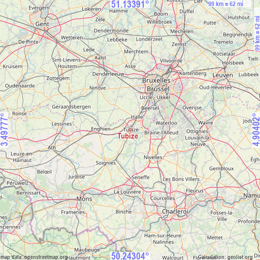
Tubize GPS coordinates[2]
50° 41' 26.124" North, 4° 12' 3.24" East
| Map corner | latitude | longitude |
|---|---|---|
| Upper-left | 51.13391°, | 3.49777° |
| Center: | 50.69059°, | 4.2009° |
| Lower-right: | 50.24304°, | 4.90402° |
| Map W x H: | 99.1×99.1 km | = 61.6×61.6mi |
| max Lat: | 51.46791° ⇑59.9% North |
| Tubize: | 50.69059° |
| min Lat: | ⇓40.1% South 49.53771° |
| min Long | Tubize | max Long |
| 2.59368° | 4.2009° | 6.25749° |
| W 31.8%⇐ | ⇒68.2% E |
Elevation
Elevation of Tubize is 39 m = 128 ft, and this is 60.5 m = 198 ft below average elevation for this country.
| Max E: |
582 m = 1909 ft | 57.2% |
| Avg. | 99.5 m = 326 ft | |
| Tubize | 39 m = 128 ft | |
Min E: |
1 m = 3 ft | 42.8% |
See also: Belgium elevation on elevation.city.
Geographical zone
Tubize is located in North temperate zone (between Tropic of Cancer and the Arctic Circle). Distance of this North polar circle is 1764.9 km =1096.7 mi to North.| Distance of | km | miles | from Tubize |
|---|---|---|---|
| North Pole | 4370.8 | 2715.9 | to North |
| Arctic Circle | 1764.9 | 1096.7 | to North |
| Tropic Cancer | 3030.3 | 1882.9 | to South |
| Equator | 5636.3 | 3502.2 | to South |


Nearby cities:
15 places around Tubize: (largest is in red/bold)
• Beersel
10.9 km =6.8 mi,  39°
39°
• Braine-l'Alleud
11.8 km =7.3 mi,  93°
93°
• Braine-le-Château
5.3 km =3.3 mi,  103°
103°
• Braine-le-Comte
9.8 km =6.1 mi,  203°
203°
• Drogenbos
13.4 km =8.3 mi, 36°
• Enghien
11.9 km =7.4 mi,  266°
266°
• Gooik
13.1 km =8.1 mi,  332°
332°
• Halle
5.4 km =3.4 mi,  26°
26°
• Herne
12.3 km =7.6 mi,  287°
287°
• Ittre
6.9 km =4.3 mi,  139°
139°
• Linkebeek
12.9 km =8 mi,  48°
48°
• Pepingen
8.2 km =5.1 mi,  339°
339°
• Rebecq-Rognon
7.9 km =4.9 mi,  236°
236°
• Sint-Genesius-Rode
12.7 km =7.9 mi,  60°
60°
• Sint-Pieters-Leeuw
10.3 km =6.4 mi,  16°
16°
Sources, notices
• [Note1] Compared only with cities in Belgium existing in our database
• [Src1] Map data: © OpenStreetMap contributors (CC-BY-SA)
• [Src2] Other city data from geonames.org with taken over terms of usage.
• [Src3] Geographical zone / Annual Mean Temperature by Robert A. Rohde @ Wikipedia
