Drogenbos geodata
Drogenbos (Flanders) is a populated place; located in Belgium in Europe/Brussels (GMT+2) time zone. With population of 4,843 people, there are 461 cities with bigger population in this country. Compared to other cities in Belgium, 50.5% of cities are located further ↑North; 63.7% of cities are located further →East and 61.2% of cities have higher elevation than Drogenbos. Note1
Administrative division(s):
- Level 1: Flanders
- Level 2: Provincie Vlaams-Brabant
- Level 3: Arrondissement Halle-Vilvoorde
- Level 4: Drogenbos


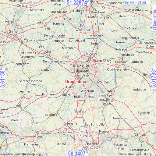
Drogenbos GPS coordinates[2]
50° 47' 14.388" North, 4° 18' 52.956" East
| Map corner | latitude | longitude |
|---|---|---|
| Upper-left | 51.22974°, | 3.61158° |
| Center: | 50.78733°, | 4.31471° |
| Lower-right: | 50.3407°, | 5.01783° |
| Map W x H: | 98.9×98.8 km | = 61.5×61.4mi |
| max Lat: | 51.46791° ⇑50.5% North |
| Drogenbos: | 50.78733° |
| min Lat: | ⇓49.5% South 49.53771° |
| min Long | Drogenbos | max Long |
| 2.59368° | 4.31471° | 6.25749° |
| W 36.3%⇐ | ⇒63.7% E |
Elevation
Elevation of Drogenbos is 31 m = 102 ft, and this is 68.5 m = 225 ft below average elevation for this country.
| Max E: |
582 m = 1909 ft | 61.2% |
| Avg. | 99.5 m = 326 ft | |
| Drogenbos | 31 m = 102 ft | |
Min E: |
1 m = 3 ft | 38.8% |
See also: Belgium elevation on elevation.city.
Geographical zone
Drogenbos is located in North temperate zone (between Tropic of Cancer and the Arctic Circle). Distance of this North polar circle is 1754.2 km =1090 mi to North.| Distance of | km | miles | from Drogenbos |
|---|---|---|---|
| North Pole | 4360 | 2709.2 | to North |
| Arctic Circle | 1754.2 | 1090 | to North |
| Tropic Cancer | 3041.1 | 1889.7 | to South |
| Equator | 5647 | 3508.9 | to South |


Nearby cities:
15 places around Drogenbos: (largest is in red/bold)
• Beersel
2.6 km =1.6 mi,  203°
203°
• Braine-l'Alleud
12.1 km =7.5 mi,  162°
162°
• Braine-le-Château
12.3 km =7.6 mi,  193°
193°
• Brussels
7.4 km =4.6 mi,  18°
18°
• Dilbeek
7.8 km =4.8 mi,  330°
330°
• Halle
8.2 km =5.1 mi,  223°
223°
• Hoeilaart
11 km =6.8 mi,  101°
101°
• Lennik
11 km =6.8 mi,  282°
282°
• Linkebeek
2.7 km =1.7 mi,  144°
144°
• Pepingen
11.3 km =7 mi,  253°
253°
• Sint-Genesius-Rode
5.5 km =3.4 mi,  146°
146°
• Sint-Martens-Lennik
10.5 km =6.5 mi, 284°
• Sint-Pieters-Leeuw
5.1 km =3.2 mi,  259°
259°
• Tubize
13.4 km =8.3 mi, 216°
• Waterloo
10 km =6.2 mi, 143°
Sources, notices
• [Note1] Compared only with cities in Belgium existing in our database
• [Src1] Map data: © OpenStreetMap contributors (CC-BY-SA)
• [Src2] Other city data from geonames.org with taken over terms of usage.
• [Src3] Geographical zone / Annual Mean Temperature by Robert A. Rohde @ Wikipedia
