Schelle geodata
Schelle (Flanders) is a populated place; located in Belgium in Europe/Brussels (GMT+2) time zone. With population of 7,675 people, there are 379 cities with bigger population in this country. Compared to other cities in Belgium, 82.7% of cities are located further ↓South; 61.9% of cities are located further →East and 93.3% of cities have higher elevation than Schelle. Note1
Administrative division(s):
- Level 1: Flanders
- Level 2: Provincie Antwerpen
- Level 3: Arrondissement Antwerpen
- Level 4: Schelle


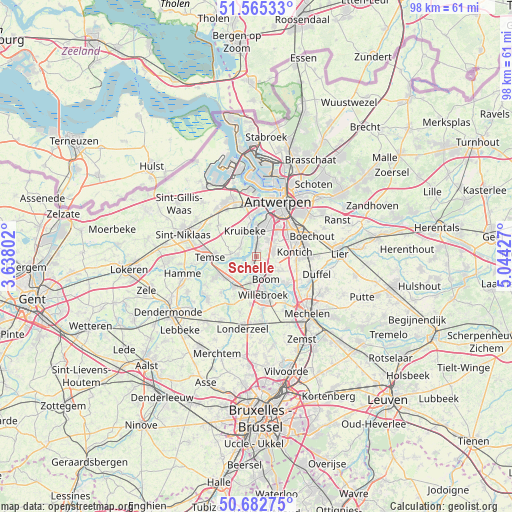
Schelle GPS coordinates[2]
51° 7' 34.14" North, 4° 20' 28.104" East
| Map corner | latitude | longitude |
|---|---|---|
| Upper-left | 51.56533°, | 3.63802° |
| Center: | 51.12615°, | 4.34114° |
| Lower-right: | 50.68275°, | 5.04427° |
| Map W x H: | 98.1×98.1 km | = 61×61mi |
| max Lat: | 51.46791° ⇑17.3% North |
| Schelle: | 51.12615° |
| min Lat: | ⇓82.7% South 49.53771° |
| min Long | Schelle | max Long |
| 2.59368° | 4.34114° | 6.25749° |
| W 38.1%⇐ | ⇒61.9% E |
Elevation
Elevation of Schelle is 7 m = 23 ft, and this is 92.5 m = 303 ft below average elevation for this country.
| Max E: |
582 m = 1909 ft | 93.3% |
| Avg. | 99.5 m = 326 ft | |
| Schelle | 7 m = 23 ft | |
Min E: |
1 m = 3 ft | 6.7% |
See also: Belgium elevation on elevation.city.
Geographical zone
Schelle is located in North temperate zone (between Tropic of Cancer and the Arctic Circle). Distance of this North polar circle is 1716.5 km =1066.6 mi to North.| Distance of | km | miles | from Schelle |
|---|---|---|---|
| North Pole | 4322.4 | 2685.8 | to North |
| Arctic Circle | 1716.5 | 1066.6 | to North |
| Tropic Cancer | 3078.8 | 1913.1 | to South |
| Equator | 5684.7 | 3532.3 | to South |


Nearby cities:
15 places around Schelle: (largest is in red/bold)
• Aartselaar
3.3 km =2.1 mi,  74°
74°
• Boom
4.3 km =2.7 mi,  150°
150°
• Bornem
7.5 km =4.7 mi,  244°
244°
• Edegem
8 km =5 mi,  64°
64°
• Hemiksem
2.1 km =1.3 mi,  355°
355°
• Hoboken
5.6 km =3.5 mi,  5°
5°
• Hove
9.6 km =6 mi, 70°
• Kontich
7.4 km =4.6 mi,  84°
84°
• Kruibeke
5.3 km =3.3 mi,  339°
339°
• Mortsel
8.9 km =5.5 mi, 59°
• Niel
1.8 km =1.1 mi,  195°
195°
• Puurs
6.9 km =4.3 mi,  212°
212°
• Rumst
7.5 km =4.7 mi,  131°
131°
• Temse
8.9 km =5.5 mi,  271°
271°
• Willebroek
7.4 km =4.6 mi,  169°
169°
Sources, notices
• [Note1] Compared only with cities in Belgium existing in our database
• [Src1] Map data: © OpenStreetMap contributors (CC-BY-SA)
• [Src2] Other city data from geonames.org with taken over terms of usage.
• [Src3] Geographical zone / Annual Mean Temperature by Robert A. Rohde @ Wikipedia
