Willebroek geodata
Willebroek (Flanders) is a populated place; located in Belgium in Europe/Brussels (GMT+2) time zone. With population of 22,808 people, there are 94 cities with bigger population in this country. Compared to other cities in Belgium, 76.9% of cities are located further ↓South; 61.2% of cities are located further →East and 98.2% of cities have higher elevation than Willebroek. Note1
Administrative division(s):
- Level 1: Flanders
- Level 2: Provincie Antwerpen
- Level 3: Arrondissement Mechelen
- Level 4: Willebroek


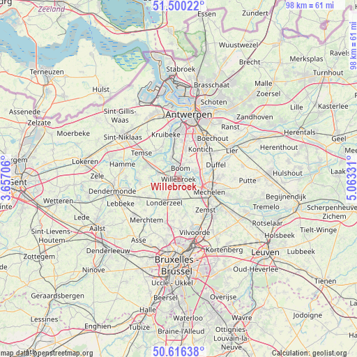
Willebroek GPS coordinates[2]
51° 3' 37.476" North, 4° 21' 36.684" East
| Map corner | latitude | longitude |
|---|---|---|
| Upper-left | 51.50022°, | 3.65706° |
| Center: | 51.06041°, | 4.36019° |
| Lower-right: | 50.61638°, | 5.06331° |
| Map W x H: | 98.3×98.3 km | = 61.1×61.1mi |
| max Lat: | 51.46791° ⇑23.1% North |
| Willebroek: | 51.06041° |
| min Lat: | ⇓76.9% South 49.53771° |
| min Long | Willebroek | max Long |
| 2.59368° | 4.36019° | 6.25749° |
| W 38.8%⇐ | ⇒61.2% E |
Elevation
Elevation of Willebroek is 4 m = 13 ft, and this is 95.5 m = 313 ft below average elevation for this country.
| Max E: |
582 m = 1909 ft | 98.2% |
| Avg. | 99.5 m = 326 ft | |
| Willebroek | 4 m = 13 ft | |
Min E: |
1 m = 3 ft | 1.8% |
See also: Belgium elevation on elevation.city.
Geographical zone
Willebroek is located in North temperate zone (between Tropic of Cancer and the Arctic Circle). Distance of this North polar circle is 1723.8 km =1071.1 mi to North.| Distance of | km | miles | from Willebroek |
|---|---|---|---|
| North Pole | 4329.7 | 2690.4 | to North |
| Arctic Circle | 1723.8 | 1071.1 | to North |
| Tropic Cancer | 3071.5 | 1908.5 | to South |
| Equator | 5677.4 | 3527.8 | to South |


Nearby cities:
15 places around Willebroek: (largest is in red/bold)
• Aartselaar
8.4 km =5.2 mi,  12°
12°
• Boom
3.6 km =2.2 mi, 12°
• Bornem
9.1 km =5.7 mi,  296°
296°
• Duffel
11.1 km =6.9 mi,  69°
69°
• Hemiksem
9.5 km =5.9 mi,  350°
350°
• Kapelle-op-den-Bos
5.6 km =3.5 mi,  177°
177°
• Kontich
10 km =6.2 mi,  37°
37°
• Londerzeel
7.4 km =4.6 mi,  212°
212°
• Mechelen
9.1 km =5.7 mi,  115°
115°
• Niel
5.9 km =3.7 mi,  342°
342°
• Puurs
5.2 km =3.2 mi,  286°
286°
• Rumst
4.9 km =3 mi,  61°
61°
• Schelle
7.4 km =4.6 mi, 349°
• Sint-Amands
10.5 km =6.5 mi,  267°
267°
• Zemst
11.1 km =6.9 mi,  140°
140°
Sources, notices
• [Note1] Compared only with cities in Belgium existing in our database
• [Src1] Map data: © OpenStreetMap contributors (CC-BY-SA)
• [Src2] Other city data from geonames.org with taken over terms of usage.
• [Src3] Geographical zone / Annual Mean Temperature by Robert A. Rohde @ Wikipedia
