Rumst geodata
Rumst (Flanders) is a populated place; located in Belgium in Europe/Brussels (GMT+2) time zone. With population of 14,521 people, there are 192 cities with bigger population in this country. Compared to other cities in Belgium, 78.7% of cities are located further ↓South; 59% of cities are located further →East and 96% of cities have higher elevation than Rumst. Note1
Administrative division(s):
- Level 1: Flanders
- Level 2: Provincie Antwerpen
- Level 3: Arrondissement Antwerpen
- Level 4: Rumst


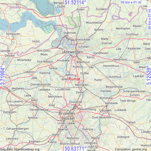
Rumst GPS coordinates[2]
51° 4' 53.508" North, 4° 25' 19.812" East
| Map corner | latitude | longitude |
|---|---|---|
| Upper-left | 51.52114°, | 3.71904° |
| Center: | 51.08153°, | 4.42217° |
| Lower-right: | 50.63771°, | 5.12529° |
| Map W x H: | 98.2×98.2 km | = 61×61mi |
| max Lat: | 51.46791° ⇑21.3% North |
| Rumst: | 51.08153° |
| min Lat: | ⇓78.7% South 49.53771° |
| min Long | Rumst | max Long |
| 2.59368° | 4.42217° | 6.25749° |
| W 41%⇐ | ⇒59% E |
Elevation
Elevation of Rumst is 6 m = 20 ft, and this is 93.5 m = 307 ft below average elevation for this country.
| Max E: |
582 m = 1909 ft | 96% |
| Avg. | 99.5 m = 326 ft | |
| Rumst | 6 m = 20 ft | |
Min E: |
1 m = 3 ft | 4% |
See also: Belgium elevation on elevation.city.
Geographical zone
Rumst is located in North temperate zone (between Tropic of Cancer and the Arctic Circle). Distance of this North polar circle is 1721.4 km =1069.6 mi to North.| Distance of | km | miles | from Rumst |
|---|---|---|---|
| North Pole | 4327.3 | 2688.9 | to North |
| Arctic Circle | 1721.4 | 1069.6 | to North |
| Tropic Cancer | 3073.8 | 1910 | to South |
| Equator | 5679.7 | 3529.2 | to South |


Nearby cities:
15 places around Rumst: (largest is in red/bold)
• Aartselaar
6.3 km =3.9 mi,  337°
337°
• Boom
3.7 km =2.3 mi,  288°
288°
• Duffel
6.3 km =3.9 mi,  75°
75°
• Edegem
8.5 km =5.3 mi,  10°
10°
• Hemiksem
9.1 km =5.7 mi,  320°
320°
• Hove
8.8 km =5.5 mi,  22°
22°
• Kapelle-op-den-Bos
9 km =5.6 mi,  207°
207°
• Kontich
5.9 km =3.7 mi, 17°
• Lint
7.3 km =4.5 mi,  45°
45°
• Mechelen
7.3 km =4.5 mi,  148°
148°
• Niel
7 km =4.3 mi,  298°
298°
• Puurs
9.4 km =5.8 mi,  264°
264°
• Schelle
7.5 km =4.7 mi,  311°
311°
• Sint-Katelijne-Waver
8 km =5 mi,  101°
101°
• Willebroek
4.9 km =3 mi,  241°
241°
Sources, notices
• [Note1] Compared only with cities in Belgium existing in our database
• [Src1] Map data: © OpenStreetMap contributors (CC-BY-SA)
• [Src2] Other city data from geonames.org with taken over terms of usage.
• [Src3] Geographical zone / Annual Mean Temperature by Robert A. Rohde @ Wikipedia
