Dour geodata
Dour (Wallonia) is a populated place; located in Belgium in Europe/Brussels (GMT+2) time zone. With population of 16,861 people, there are 160 cities with bigger population in this country. Compared to other cities in Belgium, 85% of cities are located further ↑North; 80.9% of cities are located further →East and 63.9% of cities have lower elevation than Dour. Note1
Administrative division(s):
- Level 1: Wallonia
- Level 2: Province du Hainaut
- Level 3: Arrondissement de Mons
- Level 4: Dour


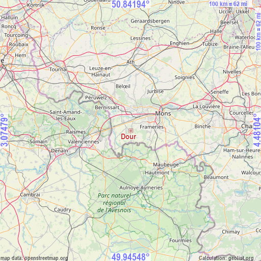
Dour GPS coordinates[2]
50° 23' 44.988" North, 3° 46' 40.512" East
| Map corner | latitude | longitude |
|---|---|---|
| Upper-left | 50.84194°, | 3.07479° |
| Center: | 50.39583°, | 3.77792° |
| Lower-right: | 49.94548°, | 4.48104° |
| Map W x H: | 99.7×99.7 km | = 62×62mi |
| max Lat: | 51.46791° ⇑85% North |
| Dour: | 50.39583° |
| min Lat: | ⇓15% South 49.53771° |
| min Long | Dour | max Long |
| 2.59368° | 3.77792° | 6.25749° |
| W 19.1%⇐ | ⇒80.9% E |
Elevation
Elevation of Dour is 93 m = 305 ft, and this is 6.5 m = 21 ft below average elevation for this country.
| Max E: |
582 m = 1909 ft | 36.1% |
| Avg. | 99.5 m = 326 ft | |
| Dour | 93 m = 305 ft | |
Min E: |
1 m = 3 ft | 63.9% |
See also: Belgium elevation on elevation.city.
Geographical zone
Dour is located in North temperate zone (between Tropic of Cancer and the Arctic Circle). Distance of this North polar circle is 1797.7 km =1117 mi to North.| Distance of | km | miles | from Dour |
|---|---|---|---|
| North Pole | 4403.6 | 2736.3 | to North |
| Arctic Circle | 1797.7 | 1117 | to North |
| Tropic Cancer | 2997.6 | 1862.6 | to South |
| Equator | 5603.5 | 3481.9 | to South |


Nearby cities:
15 places around Dour: (largest is in red/bold)
• Beloeil
17.5 km =10.9 mi,  349°
349°
• Bernissart
12.6 km =7.8 mi,  313°
313°
• Boussu
4.4 km =2.7 mi,  15°
15°
• Chasse Royale
12.7 km =7.9 mi,  73°
73°
• Colfontaine
5.9 km =3.7 mi, 69°
• Frameries
8.4 km =5.2 mi,  82°
82°
• Hensies
7.8 km =4.8 mi,  301°
301°
• Jurbise
17.7 km =11 mi,  31°
31°
• Lens
19.9 km =12.4 mi, 25°
• Mons
13.9 km =8.6 mi,  62°
62°
• Péruwelz
18.1 km =11.2 mi, 313°
• Quaregnon
7.9 km =4.9 mi,  51°
51°
• Quiévrain
6.8 km =4.2 mi,  280°
280°
• Quévy-le-Petit
11.6 km =7.2 mi,  105°
105°
• Saint-Ghislain
6.5 km =4 mi, 26°
Sources, notices
• [Note1] Compared only with cities in Belgium existing in our database
• [Src1] Map data: © OpenStreetMap contributors (CC-BY-SA)
• [Src2] Other city data from geonames.org with taken over terms of usage.
• [Src3] Geographical zone / Annual Mean Temperature by Robert A. Rohde @ Wikipedia
