Pontillas geodata
Pontillas (Wallonia) is a populated place; located in Belgium in Europe/Brussels (GMT+2) time zone. With population of 591 people, there are 546 cities with bigger population in this country. Compared to other cities in Belgium, 73.8% of cities are located further ↑North; 67% of cities are located further ←West and 81.6% of cities have lower elevation than Pontillas. Note1
Administrative division(s):
- Level 1: Wallonia
- Level 2: Province de Namur
- Level 3: Arrondissement de Namur
- Level 4: Fernelmont


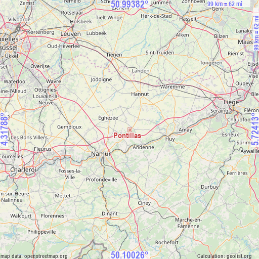
Pontillas GPS coordinates[2]
50° 32' 56.976" North, 5° 1' 15.636" East
| Map corner | latitude | longitude |
|---|---|---|
| Upper-left | 50.99382°, | 4.31788° |
| Center: | 50.54916°, | 5.02101° |
| Lower-right: | 50.10026°, | 5.72413° |
| Map W x H: | 99.4×99.4 km | = 61.8×61.8mi |
| max Lat: | 51.46791° ⇑73.8% North |
| Pontillas: | 50.54916° |
| min Lat: | ⇓26.2% South 49.53771° |
| min Long | Pontillas | max Long |
| 2.59368° | 5.02101° | 6.25749° |
| W 67%⇐ | ⇒33% E |
Elevation
Elevation of Pontillas is 186 m = 610 ft, and this is 86.5 m = 284 ft above average elevation for this country.
| Max E: |
582 m = 1909 ft | 18.4% |
| Pontillas | 186 m 610 ft | |
| Avg. | 99.5 m = 326 ft | |
Min E: |
1 m = 3 ft | 81.6% |
See also: Belgium elevation on elevation.city.
Geographical zone
Pontillas is located in North temperate zone (between Tropic of Cancer and the Arctic Circle). Distance of this North polar circle is 1780.6 km =1106.4 mi to North.| Distance of | km | miles | from Pontillas |
|---|---|---|---|
| North Pole | 4386.5 | 2725.6 | to North |
| Arctic Circle | 1780.6 | 1106.4 | to North |
| Tropic Cancer | 3014.6 | 1873.2 | to South |
| Equator | 5620.5 | 3492.4 | to South |


Nearby cities:
15 places around Pontillas: (largest is in red/bold)
• Andenne
8.5 km =5.3 mi,  141°
141°
• Braives
11 km =6.8 mi,  46°
46°
• Burdinne
5.6 km =3.5 mi,  44°
44°
• Cortil-Wodon
5 km =3.1 mi,  294°
294°
• Forville
3.2 km =2 mi,  330°
330°
• Hannut
14.2 km =8.8 mi,  16°
16°
• Hemptinne
6.4 km =4 mi,  338°
338°
• Hingeon
2.8 km =1.7 mi,  200°
200°
• Héron
5.4 km =3.4 mi,  92°
92°
• Marchovelette
6.4 km =4 mi,  242°
242°
• Noville-les-Bois
2.7 km =1.7 mi, 288°
• Ramillies
12.7 km =7.9 mi,  318°
318°
• Wanze
13.3 km =8.3 mi, 94°
• Wasseiges
8.2 km =5.1 mi,  352°
352°
• Éghezée
9 km =5.6 mi,  300°
300°
Sources, notices
• [Note1] Compared only with cities in Belgium existing in our database
• [Src1] Map data: © OpenStreetMap contributors (CC-BY-SA)
• [Src2] Other city data from geonames.org with taken over terms of usage.
• [Src3] Geographical zone / Annual Mean Temperature by Robert A. Rohde @ Wikipedia
