Wanze geodata
Wanze (Wallonia) is a populated place; located in Belgium in Europe/Brussels (GMT+2) time zone. With population of 12,918 people, there are 228 cities with bigger population in this country. Compared to other cities in Belgium, 74.4% of cities are located further ↑North; 73.3% of cities are located further ←West and 64.4% of cities have lower elevation than Wanze. Note1
Administrative division(s):
- Level 1: Wallonia
- Level 2: Province de Liège
- Level 3: Arrondissement de Huy
- Level 4: Wanze


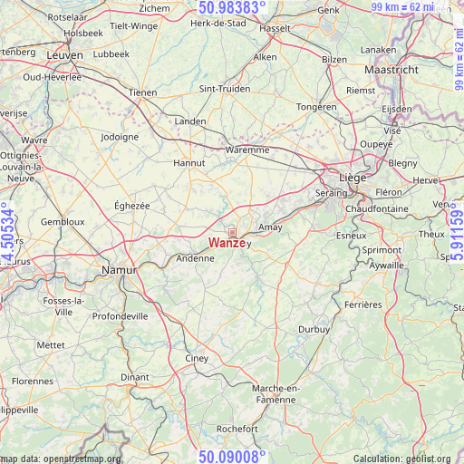
Wanze GPS coordinates[2]
50° 32' 20.652" North, 5° 12' 30.456" East
| Map corner | latitude | longitude |
|---|---|---|
| Upper-left | 50.98383°, | 4.50534° |
| Center: | 50.53907°, | 5.20846° |
| Lower-right: | 50.09008°, | 5.91159° |
| Map W x H: | 99.4×99.4 km | = 61.8×61.8mi |
| max Lat: | 51.46791° ⇑74.4% North |
| Wanze: | 50.53907° |
| min Lat: | ⇓25.6% South 49.53771° |
| min Long | Wanze | max Long |
| 2.59368° | 5.20846° | 6.25749° |
| W 73.3%⇐ | ⇒26.7% E |
Elevation
Elevation of Wanze is 96 m = 315 ft, and this is 3.5 m = 11 ft below average elevation for this country.
| Max E: |
582 m = 1909 ft | 35.6% |
| Avg. | 99.5 m = 326 ft | |
| Wanze | 96 m = 315 ft | |
Min E: |
1 m = 3 ft | 64.4% |
See also: Belgium elevation on elevation.city.
Geographical zone
Wanze is located in North temperate zone (between Tropic of Cancer and the Arctic Circle). Distance of this North polar circle is 1781.8 km =1107.2 mi to North.| Distance of | km | miles | from Wanze |
|---|---|---|---|
| North Pole | 4387.6 | 2726.3 | to North |
| Arctic Circle | 1781.8 | 1107.2 | to North |
| Tropic Cancer | 3013.5 | 1872.5 | to South |
| Equator | 5619.4 | 3491.7 | to South |


Nearby cities:
15 places around Wanze: (largest is in red/bold)
• Amay
7.2 km =4.5 mi,  81°
81°
• Andenne
9.7 km =6 mi,  235°
235°
• Braives
10.2 km =6.3 mi,  328°
328°
• Burdinne
10.6 km =6.6 mi,  298°
298°
• Engis
14.3 km =8.9 mi,  70°
70°
• Faimes
14.2 km =8.8 mi,  14°
14°
• Huy
2.8 km =1.7 mi,  142°
142°
• Héron
7.9 km =4.9 mi,  276°
276°
• Marchin
8.4 km =5.2 mi,  163°
163°
• Modave
12 km =7.5 mi,  149°
149°
• Ohey
13 km =8.1 mi,  207°
207°
• Pontillas
13.3 km =8.3 mi,  274°
274°
• Tinlot
13.9 km =8.6 mi,  120°
120°
• Verlaine
10.8 km =6.7 mi,  45°
45°
• Villers-le-Bouillet
5.6 km =3.5 mi,  40°
40°
Sources, notices
• [Note1] Compared only with cities in Belgium existing in our database
• [Src1] Map data: © OpenStreetMap contributors (CC-BY-SA)
• [Src2] Other city data from geonames.org with taken over terms of usage.
• [Src3] Geographical zone / Annual Mean Temperature by Robert A. Rohde @ Wikipedia
