Andenne geodata
Andenne (Wallonia) is a populated place; located in Belgium in Europe/Brussels (GMT+2) time zone. With population of 24,055 people, there are 86 cities with bigger population in this country. Compared to other cities in Belgium, 77.3% of cities are located further ↑North; 69.5% of cities are located further ←West and 59.4% of cities have lower elevation than Andenne. Note1
Administrative division(s):
- Level 1: Wallonia
- Level 2: Province de Namur
- Level 3: Arrondissement de Namur
- Level 4: Andenne


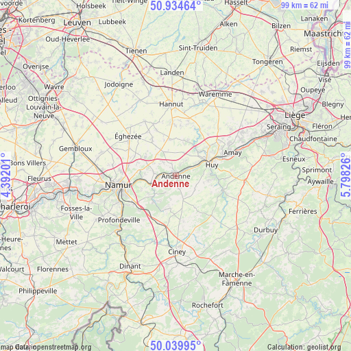
Andenne GPS coordinates[2]
50° 29' 21.876" North, 5° 5' 42.468" East
| Map corner | latitude | longitude |
|---|---|---|
| Upper-left | 50.93464°, | 4.39201° |
| Center: | 50.48941°, | 5.09513° |
| Lower-right: | 50.03995°, | 5.79826° |
| Map W x H: | 99.5×99.5 km | = 61.8×61.8mi |
| max Lat: | 51.46791° ⇑77.3% North |
| Andenne: | 50.48941° |
| min Lat: | ⇓22.7% South 49.53771° |
| min Long | Andenne | max Long |
| 2.59368° | 5.09513° | 6.25749° |
| W 69.5%⇐ | ⇒30.5% E |
Elevation
Elevation of Andenne is 78 m = 256 ft, and this is 21.5 m = 71 ft below average elevation for this country.
| Max E: |
582 m = 1909 ft | 40.6% |
| Avg. | 99.5 m = 326 ft | |
| Andenne | 78 m = 256 ft | |
Min E: |
1 m = 3 ft | 59.4% |
See also: Belgium elevation on elevation.city.
Geographical zone
Andenne is located in North temperate zone (between Tropic of Cancer and the Arctic Circle). Distance of this North polar circle is 1787.3 km =1110.6 mi to North.| Distance of | km | miles | from Andenne |
|---|---|---|---|
| North Pole | 4393.2 | 2729.8 | to North |
| Arctic Circle | 1787.3 | 1110.6 | to North |
| Tropic Cancer | 3008 | 1869.1 | to South |
| Equator | 5613.9 | 3488.3 | to South |


Nearby cities:
15 places around Andenne: (largest is in red/bold)
• Assesse
14.3 km =8.9 mi,  201°
201°
• Braives
14.5 km =9 mi,  10°
10°
• Burdinne
10.7 km =6.6 mi,  352°
352°
• Cortil-Wodon
13.1 km =8.1 mi,  311°
311°
• Forville
11.6 km =7.2 mi,  324°
324°
• Gesves
9.9 km =6.2 mi,  188°
188°
• Hingeon
7.4 km =4.6 mi,  303°
303°
• Huy
10.3 km =6.4 mi,  71°
71°
• Héron
6.4 km =4 mi,  1°
1°
• Marchin
10.7 km =6.6 mi,  103°
103°
• Marchovelette
11.6 km =7.2 mi,  288°
288°
• Noville-les-Bois
10.8 km =6.7 mi, 313°
• Ohey
6.3 km =3.9 mi,  161°
161°
• Pontillas
8.5 km =5.3 mi, 321°
• Wanze
9.7 km =6 mi,  55°
55°
Sources, notices
• [Note1] Compared only with cities in Belgium existing in our database
• [Src1] Map data: © OpenStreetMap contributors (CC-BY-SA)
• [Src2] Other city data from geonames.org with taken over terms of usage.
• [Src3] Geographical zone / Annual Mean Temperature by Robert A. Rohde @ Wikipedia
