Hannut geodata
Hannut (Wallonia) is a seat of a fourth-order administrative division; located in Belgium in Europe/Brussels (GMT+2) time zone. With population of 14,129 people, there are 204 cities with bigger population in this country. Compared to other cities in Belgium, 61.6% of cities are located further ↑North; 68.6% of cities are located further ←West and 74.4% of cities have lower elevation than Hannut. Note1
Administrative division(s):
- Level 1: Wallonia
- Level 2: Province de Liège
- Level 3: Arrondissement de Waremme
- Level 4: Hannut


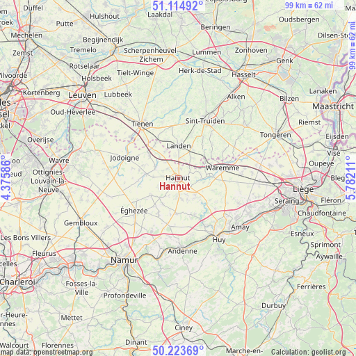
Hannut GPS coordinates[2]
50° 40' 17.112" North, 5° 4' 44.328" East
| Map corner | latitude | longitude |
|---|---|---|
| Upper-left | 51.11492°, | 4.37586° |
| Center: | 50.67142°, | 5.07898° |
| Lower-right: | 50.22369°, | 5.78211° |
| Map W x H: | 99.1×99.1 km | = 61.6×61.6mi |
| max Lat: | 51.46791° ⇑61.6% North |
| Hannut: | 50.67142° |
| min Lat: | ⇓38.4% South 49.53771° |
| min Long | Hannut | max Long |
| 2.59368° | 5.07898° | 6.25749° |
| W 68.6%⇐ | ⇒31.4% E |
Elevation
Elevation of Hannut is 140 m = 459 ft, and this is 40.5 m = 133 ft above average elevation for this country.
| Max E: |
582 m = 1909 ft | 25.6% |
| Hannut | 140 m 459 ft | |
| Avg. | 99.5 m = 326 ft | |
Min E: |
1 m = 3 ft | 74.4% |
See also: Belgium elevation on elevation.city.
Geographical zone
Hannut is located in North temperate zone (between Tropic of Cancer and the Arctic Circle). Distance of this North polar circle is 1767 km =1098 mi to North.| Distance of | km | miles | from Hannut |
|---|---|---|---|
| North Pole | 4372.9 | 2717.2 | to North |
| Arctic Circle | 1767 | 1098 | to North |
| Tropic Cancer | 3028.2 | 1881.6 | to South |
| Equator | 5634.1 | 3500.9 | to South |


Nearby cities:
15 places around Hannut: (largest is in red/bold)
• Berloz
9.9 km =6.2 mi,  72°
72°
• Braives
7.1 km =4.4 mi,  147°
147°
• Burdinne
9.7 km =6 mi,  180°
180°
• Faimes
12.8 km =8 mi,  94°
94°
• Forville
12.2 km =7.6 mi,  207°
207°
• Geer
6.7 km =4.2 mi, 91°
• Gingelom
9.4 km =5.8 mi,  24°
24°
• Hemptinne
9.9 km =6.2 mi,  219°
219°
• Héron
13.9 km =8.6 mi,  174°
174°
• Landen
9 km =5.6 mi,  1°
1°
• Lincent
5.4 km =3.4 mi,  326°
326°
• Pontillas
14.2 km =8.8 mi,  196°
196°
• Ramillies
13.2 km =8.2 mi,  251°
251°
• Waremme
12.8 km =8 mi,  76°
76°
• Wasseiges
7.6 km =4.7 mi, 223°
Sources, notices
• [Note1] Compared only with cities in Belgium existing in our database
• [Src1] Map data: © OpenStreetMap contributors (CC-BY-SA)
• [Src2] Other city data from geonames.org with taken over terms of usage.
• [Src3] Geographical zone / Annual Mean Temperature by Robert A. Rohde @ Wikipedia
