Perwez geodata
Perwez (Wallonia) is a populated place; located in Belgium in Europe/Brussels (GMT+2) time zone. With population of 7,340 people, there are 390 cities with bigger population in this country. Compared to other cities in Belgium, 66.2% of cities are located further ↑North; 58.8% of cities are located further ←West and 75.1% of cities have lower elevation than Perwez. Note1
Administrative division(s):
- Level 1: Wallonia
- Level 2: Province du Brabant Wallon
- Level 3: Arrondissement de Nivelles
- Level 4: Perwez


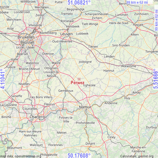
Perwez GPS coordinates[2]
50° 37' 27.336" North, 4° 48' 48.744" East
| Map corner | latitude | longitude |
|---|---|---|
| Upper-left | 51.06821°, | 4.11041° |
| Center: | 50.62426°, | 4.81354° |
| Lower-right: | 50.17608°, | 5.51666° |
| Map W x H: | 99.2×99.2 km | = 61.6×61.6mi |
| max Lat: | 51.46791° ⇑66.2% North |
| Perwez: | 50.62426° |
| min Lat: | ⇓33.8% South 49.53771° |
| min Long | Perwez | max Long |
| 2.59368° | 4.81354° | 6.25749° |
| W 58.8%⇐ | ⇒41.2% E |
Elevation
Elevation of Perwez is 147 m = 482 ft, and this is 47.5 m = 156 ft above average elevation for this country.
| Max E: |
582 m = 1909 ft | 24.9% |
| Perwez | 147 m 482 ft | |
| Avg. | 99.5 m = 326 ft | |
Min E: |
1 m = 3 ft | 75.1% |
See also: Belgium elevation on elevation.city.
Geographical zone
Perwez is located in North temperate zone (between Tropic of Cancer and the Arctic Circle). Distance of this North polar circle is 1772.3 km =1101.3 mi to North.| Distance of | km | miles | from Perwez |
|---|---|---|---|
| North Pole | 4378.2 | 2720.5 | to North |
| Arctic Circle | 1772.3 | 1101.3 | to North |
| Tropic Cancer | 3023 | 1878.4 | to South |
| Equator | 5628.9 | 3497.6 | to South |


Nearby cities:
15 places around Perwez: (largest is in red/bold)
• Chastre
12.9 km =8 mi,  258°
258°
• Chastre-Villeroux-Blanmont
12.2 km =7.6 mi, 261°
• Chaumont-Gistoux
8.8 km =5.5 mi,  312°
312°
• Cortil-Wodon
11.9 km =7.4 mi,  121°
121°
• Forville
14.2 km =8.8 mi,  113°
113°
• Gembloux
10.7 km =6.6 mi,  229°
229°
• Hemptinne
12.6 km =7.8 mi,  100°
100°
• Incourt
7.6 km =4.7 mi,  351°
351°
• Jodoigne
11.7 km =7.3 mi,  19°
19°
• Marchovelette
14.4 km =8.9 mi,  141°
141°
• Noville-les-Bois
14.2 km =8.8 mi, 121°
• Ramillies
6.3 km =3.9 mi,  80°
80°
• Walhain-Saint-Paul
8.1 km =5 mi,  271°
271°
• Wasseiges
13.5 km =8.4 mi,  91°
91°
• Éghezée
7.9 km =4.9 mi, 118°
Sources, notices
• [Note1] Compared only with cities in Belgium existing in our database
• [Src1] Map data: © OpenStreetMap contributors (CC-BY-SA)
• [Src2] Other city data from geonames.org with taken over terms of usage.
• [Src3] Geographical zone / Annual Mean Temperature by Robert A. Rohde @ Wikipedia
