Incourt geodata
Incourt (Wallonia) is a populated place; located in Belgium in Europe/Brussels (GMT+2) time zone. With population of 4,395 people, there are 475 cities with bigger population in this country. Compared to other cities in Belgium, 59.7% of cities are located further ↑North; 58.7% of cities are located further ←West and 70.6% of cities have lower elevation than Incourt. Note1
Administrative division(s):
- Level 1: Wallonia
- Level 2: Province du Brabant Wallon
- Level 3: Arrondissement de Nivelles
- Level 4: Incourt


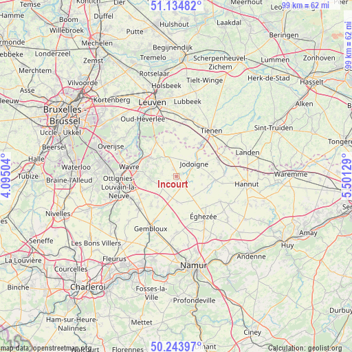
Incourt GPS coordinates[2]
50° 41' 29.436" North, 4° 47' 53.376" East
| Map corner | latitude | longitude |
|---|---|---|
| Upper-left | 51.13482°, | 4.09504° |
| Center: | 50.69151°, | 4.79816° |
| Lower-right: | 50.24397°, | 5.50129° |
| Map W x H: | 99.1×99.1 km | = 61.6×61.6mi |
| max Lat: | 51.46791° ⇑59.7% North |
| Incourt: | 50.69151° |
| min Lat: | ⇓40.3% South 49.53771° |
| min Long | Incourt | max Long |
| 2.59368° | 4.79816° | 6.25749° |
| W 58.7%⇐ | ⇒41.3% E |
Elevation
Elevation of Incourt is 125 m = 410 ft, and this is 25.5 m = 84 ft above average elevation for this country.
| Max E: |
582 m = 1909 ft | 29.4% |
| Incourt | 125 m 410 ft | |
| Avg. | 99.5 m = 326 ft | |
Min E: |
1 m = 3 ft | 70.6% |
See also: Belgium elevation on elevation.city.
Geographical zone
Incourt is located in North temperate zone (between Tropic of Cancer and the Arctic Circle). Distance of this North polar circle is 1764.8 km =1096.6 mi to North.| Distance of | km | miles | from Incourt |
|---|---|---|---|
| North Pole | 4370.7 | 2715.8 | to North |
| Arctic Circle | 1764.8 | 1096.6 | to North |
| Tropic Cancer | 3030.4 | 1883 | to South |
| Equator | 5636.4 | 3502.3 | to South |


Nearby cities:
15 places around Incourt: (largest is in red/bold)
• Beauvechain
10.2 km =6.3 mi,  349°
349°
• Bierbeek
15.5 km =9.6 mi, 349°
• Chastre
15.4 km =9.6 mi,  228°
228°
• Chastre-Villeroux-Blanmont
14.4 km =8.9 mi, 230°
• Chaumont-Gistoux
5.6 km =3.5 mi,  254°
254°
• Grez-Doiceau
8.8 km =5.5 mi,  306°
306°
• Hoegaarden
11.3 km =7 mi,  34°
34°
• Jodoigne
6.1 km =3.8 mi,  54°
54°
• Louvain-la-Neuve
13.2 km =8.2 mi,  258°
258°
• Mont-Saint-Guibert
14.7 km =9.1 mi,  244°
244°
• Perwez
7.6 km =4.7 mi,  171°
171°
• Ramillies
9.7 km =6 mi,  131°
131°
• Walhain-Saint-Paul
10.1 km =6.3 mi,  224°
224°
• Wavre
14.1 km =8.8 mi,  281°
281°
• Éghezée
13.8 km =8.6 mi,  144°
144°
Sources, notices
• [Note1] Compared only with cities in Belgium existing in our database
• [Src1] Map data: © OpenStreetMap contributors (CC-BY-SA)
• [Src2] Other city data from geonames.org with taken over terms of usage.
• [Src3] Geographical zone / Annual Mean Temperature by Robert A. Rohde @ Wikipedia
