Nivelles geodata
Nivelles (Wallonia) is a populated place; located in Belgium in Europe/Brussels (GMT+2) time zone. With population of 24,149 people, there are 85 cities with bigger population in this country. Compared to other cities in Belgium, 69.3% of cities are located further ↑North; 62.6% of cities are located further →East and 66.2% of cities have lower elevation than Nivelles. Note1
Administrative division(s):
- Level 1: Wallonia
- Level 2: Province du Brabant Wallon
- Level 3: Arrondissement de Nivelles
- Level 4: Nivelles


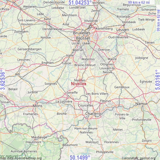
Nivelles GPS coordinates[2]
50° 35' 53.988" North, 4° 19' 42.528" East
| Map corner | latitude | longitude |
|---|---|---|
| Upper-left | 51.04253°, | 3.62536° |
| Center: | 50.59833°, | 4.32848° |
| Lower-right: | 50.1499°, | 5.03161° |
| Map W x H: | 99.3×99.2 km | = 61.7×61.6mi |
| max Lat: | 51.46791° ⇑69.3% North |
| Nivelles: | 50.59833° |
| min Lat: | ⇓30.7% South 49.53771° |
| min Long | Nivelles | max Long |
| 2.59368° | 4.32848° | 6.25749° |
| W 37.4%⇐ | ⇒62.6% E |
Elevation
Elevation of Nivelles is 101 m = 331 ft, and this is 1.5 m = 5 ft above average elevation for this country.
| Max E: |
582 m = 1909 ft | 33.8% |
| Nivelles | 101 m 331 ft | |
| Avg. | 99.5 m = 326 ft | |
Min E: |
1 m = 3 ft | 66.2% |
See also: Belgium elevation on elevation.city.
Geographical zone
Nivelles is located in North temperate zone (between Tropic of Cancer and the Arctic Circle). Distance of this North polar circle is 1775.2 km =1103.1 mi to North.| Distance of | km | miles | from Nivelles |
|---|---|---|---|
| North Pole | 4381.1 | 2722.3 | to North |
| Arctic Circle | 1775.2 | 1103.1 | to North |
| Tropic Cancer | 3020.1 | 1876.6 | to South |
| Equator | 5626 | 3495.8 | to South |


Nearby cities:
15 places around Nivelles: (largest is in red/bold)
• Braine-l'Alleud
9.9 km =6.2 mi,  16°
16°
• Braine-le-Château
9.9 km =6.2 mi,  336°
336°
• Braine-le-Comte
12.9 km =8 mi,  275°
275°
• Brunehault
12.7 km =7.9 mi,  144°
144°
• Chapelle-lez-Herlaimont
14.5 km =9 mi,  193°
193°
• Courcelles
15.3 km =9.5 mi,  167°
167°
• Genappe
8.8 km =5.5 mi,  80°
80°
• Ittre
6.8 km =4.2 mi,  318°
318°
• Manage
12.4 km =7.7 mi,  211°
211°
• Pont-à-Celles
10.7 km =6.6 mi,  164°
164°
• Seneffe
8.8 km =5.5 mi, 211°
• Tubize
13.6 km =8.5 mi, 318°
• Villers-la-Ville
13.7 km =8.5 mi,  104°
104°
• Waterloo
13.9 km =8.6 mi, 21°
• Écaussinnes-d’Enghien
12 km =7.5 mi,  253°
253°
Sources, notices
• [Note1] Compared only with cities in Belgium existing in our database
• [Src1] Map data: © OpenStreetMap contributors (CC-BY-SA)
• [Src2] Other city data from geonames.org with taken over terms of usage.
• [Src3] Geographical zone / Annual Mean Temperature by Robert A. Rohde @ Wikipedia
