Ittre geodata
Ittre (Wallonia) is a populated place; located in Belgium in Europe/Brussels (GMT+2) time zone. With population of 6,014 people, there are 424 cities with bigger population in this country. Compared to other cities in Belgium, 64.3% of cities are located further ↑North; 65.7% of cities are located further →East and 67.5% of cities have lower elevation than Ittre. Note1
Administrative division(s):
- Level 1: Wallonia
- Level 2: Province du Brabant Wallon
- Level 3: Arrondissement de Nivelles
- Level 4: Ittre


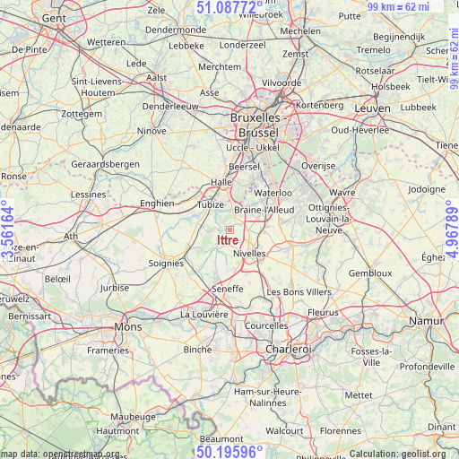
Ittre GPS coordinates[2]
50° 38' 38.256" North, 4° 15' 53.136" East
| Map corner | latitude | longitude |
|---|---|---|
| Upper-left | 51.08772°, | 3.56164° |
| Center: | 50.64396°, | 4.26476° |
| Lower-right: | 50.19596°, | 4.96789° |
| Map W x H: | 99.2×99.2 km | = 61.6×61.6mi |
| max Lat: | 51.46791° ⇑64.3% North |
| Ittre: | 50.64396° |
| min Lat: | ⇓35.7% South 49.53771° |
| min Long | Ittre | max Long |
| 2.59368° | 4.26476° | 6.25749° |
| W 34.3%⇐ | ⇒65.7% E |
Elevation
Elevation of Ittre is 111 m = 364 ft, and this is 11.5 m = 38 ft above average elevation for this country.
| Max E: |
582 m = 1909 ft | 32.5% |
| Ittre | 111 m 364 ft | |
| Avg. | 99.5 m = 326 ft | |
Min E: |
1 m = 3 ft | 67.5% |
See also: Belgium elevation on elevation.city.
Geographical zone
Ittre is located in North temperate zone (between Tropic of Cancer and the Arctic Circle). Distance of this North polar circle is 1770.1 km =1099.9 mi to North.| Distance of | km | miles | from Ittre |
|---|---|---|---|
| North Pole | 4376 | 2719.1 | to North |
| Arctic Circle | 1770.1 | 1099.9 | to North |
| Tropic Cancer | 3025.2 | 1879.8 | to South |
| Equator | 5631.1 | 3499 | to South |


Nearby cities:
15 places around Ittre: (largest is in red/bold)
• Beersel
13.8 km =8.6 mi,  10°
10°
• Braine-l'Alleud
8.5 km =5.3 mi,  58°
58°
• Braine-le-Château
4 km =2.5 mi, 9°
• Braine-le-Comte
9.2 km =5.7 mi,  245°
245°
• Genappe
13.7 km =8.5 mi,  105°
105°
• Halle
10.2 km =6.3 mi,  347°
347°
• Linkebeek
14.7 km =9.1 mi,  20°
20°
• Nivelles
6.8 km =4.2 mi,  138°
138°
• Pepingen
14.8 km =9.2 mi,  330°
330°
• Rebecq-Rognon
11.2 km =7 mi,  274°
274°
• Seneffe
12.5 km =7.8 mi,  180°
180°
• Sint-Genesius-Rode
13.1 km =8.1 mi,  29°
29°
• Tubize
6.9 km =4.3 mi,  319°
319°
• Waterloo
12.3 km =7.6 mi,  50°
50°
• Écaussinnes-d’Enghien
10.9 km =6.8 mi,  219°
219°
Sources, notices
• [Note1] Compared only with cities in Belgium existing in our database
• [Src1] Map data: © OpenStreetMap contributors (CC-BY-SA)
• [Src2] Other city data from geonames.org with taken over terms of usage.
• [Src3] Geographical zone / Annual Mean Temperature by Robert A. Rohde @ Wikipedia
