Seneffe geodata
Seneffe (Wallonia) is a populated place; located in Belgium in Europe/Brussels (GMT+2) time zone. With population of 11,025 people, there are 272 cities with bigger population in this country. Compared to other cities in Belgium, 74.9% of cities are located further ↑North; 65.9% of cities are located further →East and 67.7% of cities have lower elevation than Seneffe. Note1
Administrative division(s):
- Level 1: Wallonia
- Level 2: Province du Hainaut
- Level 3: Arrondissement de Charleroi
- Level 4: Seneffe


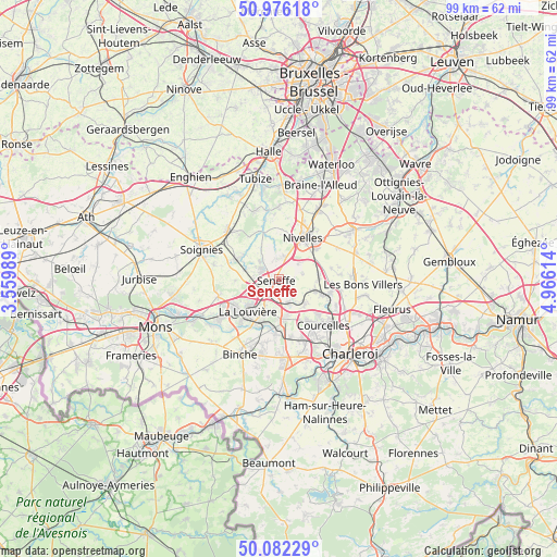
Seneffe GPS coordinates[2]
50° 31' 52.86" North, 4° 15' 46.836" East
| Map corner | latitude | longitude |
|---|---|---|
| Upper-left | 50.97618°, | 3.55989° |
| Center: | 50.53135°, | 4.26301° |
| Lower-right: | 50.08229°, | 4.96614° |
| Map W x H: | 99.4×99.4 km | = 61.8×61.8mi |
| max Lat: | 51.46791° ⇑74.9% North |
| Seneffe: | 50.53135° |
| min Lat: | ⇓25.1% South 49.53771° |
| min Long | Seneffe | max Long |
| 2.59368° | 4.26301° | 6.25749° |
| W 34.1%⇐ | ⇒65.9% E |
Elevation
Elevation of Seneffe is 112 m = 367 ft, and this is 12.5 m = 41 ft above average elevation for this country.
| Max E: |
582 m = 1909 ft | 32.3% |
| Seneffe | 112 m 367 ft | |
| Avg. | 99.5 m = 326 ft | |
Min E: |
1 m = 3 ft | 67.7% |
See also: Belgium elevation on elevation.city.
Geographical zone
Seneffe is located in North temperate zone (between Tropic of Cancer and the Arctic Circle). Distance of this North polar circle is 1782.6 km =1107.7 mi to North.| Distance of | km | miles | from Seneffe |
|---|---|---|---|
| North Pole | 4388.5 | 2726.9 | to North |
| Arctic Circle | 1782.6 | 1107.7 | to North |
| Tropic Cancer | 3012.6 | 1871.9 | to South |
| Equator | 5618.6 | 3491.2 | to South |


Nearby cities:
15 places around Seneffe: (largest is in red/bold)
• Anderlues
13.8 km =8.6 mi,  177°
177°
• Binche
15 km =9.3 mi,  207°
207°
• Braine-le-Comte
12 km =7.5 mi,  316°
316°
• Brunehault
12.3 km =7.6 mi,  103°
103°
• Chapelle-lez-Herlaimont
6.8 km =4.2 mi,  168°
168°
• Courcelles
10.9 km =6.8 mi,  133°
133°
• Ittre
12.5 km =7.8 mi,  0°
0°
• La Louvière
7.3 km =4.5 mi,  226°
226°
• Manage
3.7 km =2.3 mi, 211°
• Morlanwelz-Mariemont
8.6 km =5.3 mi,  188°
188°
• Nivelles
8.8 km =5.5 mi,  31°
31°
• Pont-à-Celles
8 km =5 mi,  111°
111°
• Roeulx
11.1 km =6.9 mi,  253°
253°
• Soignies
14.5 km =9 mi,  291°
291°
• Écaussinnes-d’Enghien
8 km =5 mi,  300°
300°
Sources, notices
• [Note1] Compared only with cities in Belgium existing in our database
• [Src1] Map data: © OpenStreetMap contributors (CC-BY-SA)
• [Src2] Other city data from geonames.org with taken over terms of usage.
• [Src3] Geographical zone / Annual Mean Temperature by Robert A. Rohde @ Wikipedia
