Nieuwpoort geodata
Nieuwpoort (Flanders) is a populated place; located in Belgium in Europe/Brussels (GMT+2) time zone. With population of 10,845 people, there are 281 cities with bigger population in this country. Compared to other cities in Belgium, 83.2% of cities are located further ↓South; 98.9% of cities are located further →East and 88.4% of cities have higher elevation than Nieuwpoort. Note1
Administrative division(s):
- Level 1: Flanders
- Level 2: Provincie West-Vlaanderen
- Level 3: Arrondissement Veurne
- Level 4: Nieuwpoort


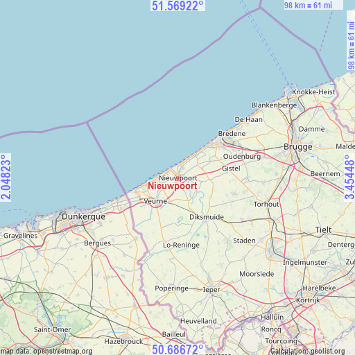
Nieuwpoort GPS coordinates[2]
51° 7' 48.288" North, 2° 45' 4.86" East
| Map corner | latitude | longitude |
|---|---|---|
| Upper-left | 51.56922°, | 2.04823° |
| Center: | 51.13008°, | 2.75135° |
| Lower-right: | 50.68672°, | 3.45448° |
| Map W x H: | 98.1×98.1 km | = 61×61mi |
| max Lat: | 51.46791° ⇑16.8% North |
| Nieuwpoort: | 51.13008° |
| min Lat: | ⇓83.2% South 49.53771° |
| min Long | Nieuwpoort | max Long |
| 2.59368° | 2.75135° | 6.25749° |
| W 1.1%⇐ | ⇒98.9% E |
Elevation
Elevation of Nieuwpoort is 9 m = 30 ft, and this is 90.5 m = 297 ft below average elevation for this country.
| Max E: |
582 m = 1909 ft | 88.4% |
| Avg. | 99.5 m = 326 ft | |
| Nieuwpoort | 9 m = 30 ft | |
Min E: |
1 m = 3 ft | 11.6% |
See also: Belgium elevation on elevation.city.
Geographical zone
Nieuwpoort is located in North temperate zone (between Tropic of Cancer and the Arctic Circle). Distance of this North polar circle is 1716 km =1066.3 mi to North.| Distance of | km | miles | from Nieuwpoort |
|---|---|---|---|
| North Pole | 4321.9 | 2685.5 | to North |
| Arctic Circle | 1716 | 1066.3 | to North |
| Tropic Cancer | 3079.2 | 1913.3 | to South |
| Equator | 5685.1 | 3532.6 | to South |


Nearby cities:
15 places around Nieuwpoort: (largest is in red/bold)
• Alveringem
13.4 km =8.3 mi,  192°
192°
• Bredene
19.5 km =12.1 mi,  53°
53°
• De Panne
11.6 km =7.2 mi,  252°
252°
• Diksmuide
13.4 km =8.3 mi,  144°
144°
• Gistel
15.1 km =9.4 mi,  78°
78°
• Houthulst
21.9 km =13.6 mi, 140°
• Ichtegem
18.8 km =11.7 mi,  101°
101°
• Koekelare
16.4 km =10.2 mi,  105°
105°
• Koksijde
8.1 km =5 mi,  259°
259°
• Kortemark
23.1 km =14.4 mi,  118°
118°
• Middelkerke
7.8 km =4.8 mi,  38°
38°
• Oostduinkerke
5.1 km =3.2 mi, 251°
• Ostend
15.5 km =9.6 mi, 52°
• Oudenburg
18.4 km =11.4 mi,  70°
70°
• Veurne
8.6 km =5.3 mi,  222°
222°
Sources, notices
• [Note1] Compared only with cities in Belgium existing in our database
• [Src1] Map data: © OpenStreetMap contributors (CC-BY-SA)
• [Src2] Other city data from geonames.org with taken over terms of usage.
• [Src3] Geographical zone / Annual Mean Temperature by Robert A. Rohde @ Wikipedia
