Gistel geodata
Gistel (Flanders) is a populated place; located in Belgium in Europe/Brussels (GMT+2) time zone. With population of 11,084 people, there are 270 cities with bigger population in this country. Compared to other cities in Belgium, 86.3% of cities are located further ↓South; 97.5% of cities are located further →East and 93.3% of cities have higher elevation than Gistel. Note1
Administrative division(s):
- Level 1: Flanders
- Level 2: Provincie West-Vlaanderen
- Level 3: Arrondissement Oostende
- Level 4: Gistel


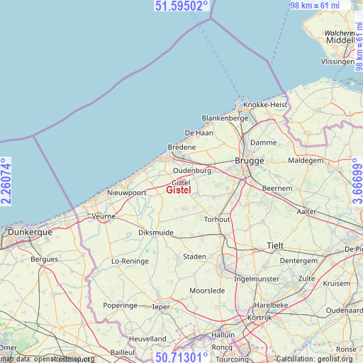
Gistel GPS coordinates[2]
51° 9' 22.032" North, 2° 57' 49.932" East
| Map corner | latitude | longitude |
|---|---|---|
| Upper-left | 51.59502°, | 2.26074° |
| Center: | 51.15612°, | 2.96387° |
| Lower-right: | 50.71301°, | 3.66699° |
| Map W x H: | 98.1×98.1 km | = 61×61mi |
| max Lat: | 51.46791° ⇑13.7% North |
| Gistel: | 51.15612° |
| min Lat: | ⇓86.3% South 49.53771° |
| min Long | Gistel | max Long |
| 2.59368° | 2.96387° | 6.25749° |
| W 2.5%⇐ | ⇒97.5% E |
Elevation
Elevation of Gistel is 7 m = 23 ft, and this is 92.5 m = 303 ft below average elevation for this country.
| Max E: |
582 m = 1909 ft | 93.3% |
| Avg. | 99.5 m = 326 ft | |
| Gistel | 7 m = 23 ft | |
Min E: |
1 m = 3 ft | 6.7% |
See also: Belgium elevation on elevation.city.
Geographical zone
Gistel is located in North temperate zone (between Tropic of Cancer and the Arctic Circle). Distance of this North polar circle is 1713.1 km =1064.5 mi to North.| Distance of | km | miles | from Gistel |
|---|---|---|---|
| North Pole | 4319 | 2683.7 | to North |
| Arctic Circle | 1713.1 | 1064.5 | to North |
| Tropic Cancer | 3082.1 | 1915.1 | to South |
| Equator | 5688 | 3534.4 | to South |


Nearby cities:
15 places around Gistel: (largest is in red/bold)
• Bredene
8.8 km =5.5 mi,  5°
5°
• De Haan
13.9 km =8.6 mi,  20°
20°
• Diksmuide
15.4 km =9.6 mi,  206°
206°
• Ichtegem
7.6 km =4.7 mi,  151°
151°
• Jabbeke
9.2 km =5.7 mi,  71°
71°
• Koekelare
7.4 km =4.6 mi,  172°
172°
• Kortemark
15.1 km =9.4 mi,  159°
159°
• Middelkerke
10.5 km =6.5 mi,  288°
288°
• Nieuwpoort
15.1 km =9.4 mi,  258°
258°
• Ostend
7.1 km =4.4 mi,  338°
338°
• Oudenburg
4.1 km =2.5 mi,  38°
38°
• Torhout
13.9 km =8.6 mi,  136°
136°
• Wenduine
17.8 km =11.1 mi,  27°
27°
• Zedelgem
12.2 km =7.6 mi,  97°
97°
• Zuienkerke
18 km =11.2 mi,  47°
47°
Sources, notices
• [Note1] Compared only with cities in Belgium existing in our database
• [Src1] Map data: © OpenStreetMap contributors (CC-BY-SA)
• [Src2] Other city data from geonames.org with taken over terms of usage.
• [Src3] Geographical zone / Annual Mean Temperature by Robert A. Rohde @ Wikipedia
