Ostend geodata
Ostend (Flanders) is a seat of a third-order administrative division; located in Belgium in Europe/Brussels (GMT+2) time zone. With population of 69,011 people, there are 15 cities with bigger population in this country. Compared to other cities in Belgium, 92.1% of cities are located further ↓South; 97.8% of cities are located further →East and 96% of cities have higher elevation than Ostend. Note1
Administrative division(s):
- Level 1: Flanders
- Level 2: Provincie West-Vlaanderen
- Level 3: Arrondissement Oostende
- Level 4: Oostende


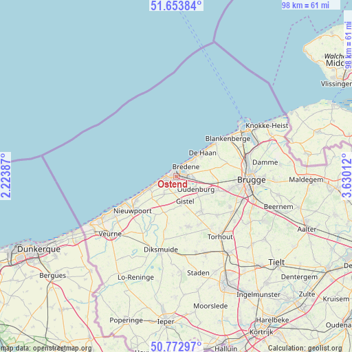
Ostend GPS coordinates[2]
51° 12' 55.836" North, 2° 55' 37.2" East
| Map corner | latitude | longitude |
|---|---|---|
| Upper-left | 51.65384°, | 2.22387° |
| Center: | 51.21551°, | 2.927° |
| Lower-right: | 50.77297°, | 3.63012° |
| Map W x H: | 97.9×97.9 km | = 60.8×60.8mi |
| max Lat: | 51.46791° ⇑7.9% North |
| Ostend: | 51.21551° |
| min Lat: | ⇓92.1% South 49.53771° |
| min Long | Ostend | max Long |
| 2.59368° | 2.927° | 6.25749° |
| W 2.2%⇐ | ⇒97.8% E |
Elevation
Elevation of Ostend is 6 m = 20 ft, and this is 93.5 m = 307 ft below average elevation for this country.
| Max E: |
582 m = 1909 ft | 96% |
| Avg. | 99.5 m = 326 ft | |
| Ostend | 6 m = 20 ft | |
Min E: |
1 m = 3 ft | 4% |
See also: Ostend elevation on elevation.city.
Geographical zone
Ostend is located in North temperate zone (between Tropic of Cancer and the Arctic Circle). Distance of this North polar circle is 1706.5 km =1060.4 mi to North.| Distance of | km | miles | from Ostend |
|---|---|---|---|
| North Pole | 4312.4 | 2679.6 | to North |
| Arctic Circle | 1706.5 | 1060.4 | to North |
| Tropic Cancer | 3088.7 | 1919.2 | to South |
| Equator | 5694.6 | 3538.5 | to South |


Nearby cities:
15 places around Ostend: (largest is in red/bold)
• Blankenberge
17.9 km =11.1 mi,  52°
52°
• Bredene
4 km =2.5 mi,  57°
57°
• De Haan
9.8 km =6.1 mi, 49°
• Gistel
7.1 km =4.4 mi,  158°
158°
• Ichtegem
14.7 km =9.1 mi, 155°
• Jabbeke
11.9 km =7.4 mi,  108°
108°
• Koekelare
14.4 km =8.9 mi,  165°
165°
• Middelkerke
8.1 km =5 mi,  245°
245°
• Nieuwpoort
15.5 km =9.6 mi,  232°
232°
• Oostduinkerke
20.4 km =12.7 mi,  236°
236°
• Oudenburg
6.1 km =3.8 mi,  123°
123°
• Torhout
20.6 km =12.8 mi,  143°
143°
• Wenduine
14.2 km =8.8 mi, 49°
• Zedelgem
16.7 km =10.4 mi, 119°
• Zuienkerke
16.8 km =10.4 mi,  70°
70°
In other languages:
- In Spanish: Ostende
- In France: Ostende
- In German: Ostende
- In Italian: Ostenda
- In Russian: Остенде
- In Chinese: 奥斯滕德
Sources, notices
• [Note1] Compared only with cities in Belgium existing in our database
• [Src1] Map data: © OpenStreetMap contributors (CC-BY-SA)
• [Src2] Other city data from geonames.org with taken over terms of usage.
• [Src3] Geographical zone / Annual Mean Temperature by Robert A. Rohde @ Wikipedia
