De Panne geodata
De Panne (Flanders) is a populated place; located in Belgium in Europe/Brussels (GMT+2) time zone. With population of 9,799 people, there are 308 cities with bigger population in this country. Compared to other cities in Belgium, 80.3% of cities are located further ↓South; 100% of cities are located further →East and 83.8% of cities have higher elevation than De Panne. Note1
Administrative division(s):
- Level 1: Flanders
- Level 2: Provincie West-Vlaanderen
- Level 3: Arrondissement Veurne
- Level 4: De Panne


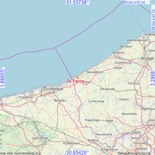
De Panne GPS coordinates[2]
51° 5' 52.548" North, 2° 35' 37.248" East
| Map corner | latitude | longitude |
|---|---|---|
| Upper-left | 51.53738°, | 1.89055° |
| Center: | 51.09793°, | 2.59368° |
| Lower-right: | 50.65426°, | 3.2968° |
| Map W x H: | 98.2×98.2 km | = 61×61mi |
| max Lat: | 51.46791° ⇑19.7% North |
| De Panne: | 51.09793° |
| min Lat: | ⇓80.3% South 49.53771° |
| min Long | De Panne | max Long |
| 2.59368° | 2.59368° | 6.25749° |
| W 0%⇐ | ⇒100% E |
Elevation
Elevation of De Panne is 11 m = 36 ft, and this is 88.5 m = 290 ft below average elevation for this country.
| Max E: |
582 m = 1909 ft | 83.8% |
| Avg. | 99.5 m = 326 ft | |
| De Panne | 11 m = 36 ft | |
Min E: |
1 m = 3 ft | 16.2% |
See also: Belgium elevation on elevation.city.
Geographical zone
De Panne is located in North temperate zone (between Tropic of Cancer and the Arctic Circle). Distance of this North polar circle is 1719.6 km =1068.5 mi to North.| Distance of | km | miles | from De Panne |
|---|---|---|---|
| North Pole | 4325.5 | 2687.7 | to North |
| Arctic Circle | 1719.6 | 1068.5 | to North |
| Tropic Cancer | 3075.6 | 1911.1 | to South |
| Equator | 5681.6 | 3530.4 | to South |


Nearby cities:
15 places around De Panne: (largest is in red/bold)
• Alveringem
12.6 km =7.8 mi,  139°
139°
• Bredene
30.7 km =19.1 mi,  60°
60°
• Diksmuide
20.2 km =12.6 mi,  111°
111°
• Gistel
26.6 km =16.5 mi,  75°
75°
• Houthulst
28.3 km =17.6 mi,  118°
118°
• Ichtegem
29.5 km =18.3 mi,  90°
90°
• Koekelare
26.9 km =16.7 mi, 91°
• Koksijde
3.7 km =2.3 mi, 56°
• Middelkerke
18.6 km =11.6 mi, 58°
• Nieuwpoort
11.6 km =7.2 mi,  72°
72°
• Oostduinkerke
6.5 km =4 mi, 72°
• Ostend
26.7 km =16.6 mi, 60°
• Oudenburg
30 km =18.6 mi, 71°
• Poperinge
28.7 km =17.8 mi,  161°
161°
• Veurne
5.9 km =3.7 mi, 117°
Sources, notices
• [Note1] Compared only with cities in Belgium existing in our database
• [Src1] Map data: © OpenStreetMap contributors (CC-BY-SA)
• [Src2] Other city data from geonames.org with taken over terms of usage.
• [Src3] Geographical zone / Annual Mean Temperature by Robert A. Rohde @ Wikipedia
