Manhay geodata
Manhay (Wallonia) is a populated place; located in Belgium in Europe/Brussels (GMT+2) time zone. With population of 3,128 people, there are 503 cities with bigger population in this country. Compared to other cities in Belgium, 89.2% of cities are located further ↑North; 91.3% of cities are located further ←West and 98.6% of cities have lower elevation than Manhay. Note1
Administrative division(s):
- Level 1: Wallonia
- Level 2: Province du Luxembourg
- Level 3: Arrondissement de Marche-en-Famenne
- Level 4: Manhay


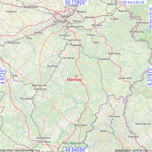
Manhay GPS coordinates[2]
50° 17' 31.884" North, 5° 40' 32.232" East
| Map corner | latitude | longitude |
|---|---|---|
| Upper-left | 50.73928°, | 4.9725° |
| Center: | 50.29219°, | 5.67562° |
| Lower-right: | 49.84086°, | 6.37875° |
| Map W x H: | 99.9×99.9 km | = 62.1×62.1mi |
| max Lat: | 51.46791° ⇑89.2% North |
| Manhay: | 50.29219° |
| min Lat: | ⇓10.8% South 49.53771° |
| min Long | Manhay | max Long |
| 2.59368° | 5.67562° | 6.25749° |
| W 91.3%⇐ | ⇒8.7% E |
Elevation
Elevation of Manhay is 440 m = 1444 ft, and this is 340.5 m = 1117 ft above average elevation for this country.
| Max E: |
582 m = 1909 ft | 1.4% |
| Manhay | 440 m 1444 ft | |
| Avg. | 99.5 m = 326 ft | |
Min E: |
1 m = 3 ft | 98.6% |
See also: Belgium elevation on elevation.city.
Geographical zone
Manhay is located in North temperate zone (between Tropic of Cancer and the Arctic Circle). Distance of this North polar circle is 1809.2 km =1124.2 mi to North.| Distance of | km | miles | from Manhay |
|---|---|---|---|
| North Pole | 4415.1 | 2743.4 | to North |
| Arctic Circle | 1809.2 | 1124.2 | to North |
| Tropic Cancer | 2986 | 1855.4 | to South |
| Equator | 5592 | 3474.7 | to South |


Nearby cities:
15 places around Manhay: (largest is in red/bold)
• Aywaille
20.2 km =12.6 mi,  0°
0°
• Comblain-au-Pont
21.5 km =13.4 mi,  341°
341°
• Durbuy
17 km =10.6 mi,  293°
293°
• Ferrières
13 km =8.1 mi, 339°
• Hamoir
18.1 km =11.2 mi,  325°
325°
• Hotton
16.5 km =10.3 mi,  260°
260°
• Houffalize
19.5 km =12.1 mi,  155°
155°
• La Roche-en-Ardenne
14 km =8.7 mi,  210°
210°
• Lierneux
8.3 km =5.2 mi,  95°
95°
• Rendeux
13.8 km =8.6 mi,  242°
242°
• Stavelot
21.4 km =13.3 mi,  57°
57°
• Stoumont
15.8 km =9.8 mi,  36°
36°
• Trois-Ponts
16.4 km =10.2 mi, 57°
• Vielsalm
17 km =10.6 mi,  93°
93°
• Érezée
8.3 km =5.2 mi,  270°
270°
Sources, notices
• [Note1] Compared only with cities in Belgium existing in our database
• [Src1] Map data: © OpenStreetMap contributors (CC-BY-SA)
• [Src2] Other city data from geonames.org with taken over terms of usage.
• [Src3] Geographical zone / Annual Mean Temperature by Robert A. Rohde @ Wikipedia
