Rendeux geodata
Rendeux (Wallonia) is a populated place; located in Belgium in Europe/Brussels (GMT+2) time zone. With population of 2,320 people, there are 528 cities with bigger population in this country. Compared to other cities in Belgium, 91% of cities are located further ↑North; 84.7% of cities are located further ←West and 82.3% of cities have lower elevation than Rendeux. Note1
Administrative division(s):
- Level 1: Wallonia
- Level 2: Province du Luxembourg
- Level 3: Arrondissement de Marche-en-Famenne
- Level 4: Rendeux


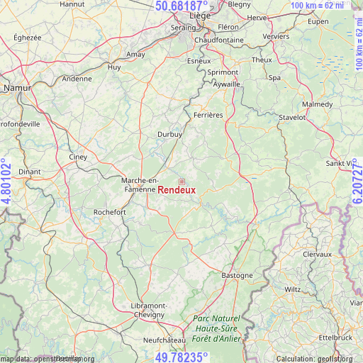
Rendeux GPS coordinates[2]
50° 14' 3.228" North, 5° 30' 14.904" East
| Map corner | latitude | longitude |
|---|---|---|
| Upper-left | 50.68187°, | 4.80102° |
| Center: | 50.23423°, | 5.50414° |
| Lower-right: | 49.78235°, | 6.20727° |
| Map W x H: | 100×100 km | = 62.1×62.1mi |
| max Lat: | 51.46791° ⇑91% North |
| Rendeux: | 50.23423° |
| min Lat: | ⇓9% South 49.53771° |
| min Long | Rendeux | max Long |
| 2.59368° | 5.50414° | 6.25749° |
| W 84.7%⇐ | ⇒15.3% E |
Elevation
Elevation of Rendeux is 194 m = 636 ft, and this is 94.5 m = 310 ft above average elevation for this country.
| Max E: |
582 m = 1909 ft | 17.7% |
| Rendeux | 194 m 636 ft | |
| Avg. | 99.5 m = 326 ft | |
Min E: |
1 m = 3 ft | 82.3% |
See also: Belgium elevation on elevation.city.
Geographical zone
Rendeux is located in North temperate zone (between Tropic of Cancer and the Arctic Circle). Distance of this North polar circle is 1815.7 km =1128.2 mi to North.| Distance of | km | miles | from Rendeux |
|---|---|---|---|
| North Pole | 4421.5 | 2747.4 | to North |
| Arctic Circle | 1815.7 | 1128.2 | to North |
| Tropic Cancer | 2979.6 | 1851.4 | to South |
| Equator | 5585.5 | 3470.7 | to South |


Nearby cities:
15 places around Rendeux: (largest is in red/bold)
• Bertogne
20.4 km =12.7 mi,  145°
145°
• Clavier
21.4 km =13.3 mi,  329°
329°
• Durbuy
13.6 km =8.5 mi,  345°
345°
• Ferrières
20.1 km =12.5 mi,  22°
22°
• Hamoir
21.5 km =13.4 mi,  5°
5°
• Hotton
5.5 km =3.4 mi,  311°
311°
• La Roche-en-Ardenne
7.6 km =4.7 mi,  137°
137°
• Lierneux
21.2 km =13.2 mi,  74°
74°
• Manhay
13.8 km =8.6 mi,  62°
62°
• Marche-en-Famenne
11.4 km =7.1 mi,  265°
265°
• Nassogne
16.4 km =10.2 mi,  224°
224°
• Rochefort
21.6 km =13.4 mi,  248°
248°
• Somme-Leuze
15 km =9.3 mi,  319°
319°
• Tenneville
15.6 km =9.7 mi,  173°
173°
• Érezée
7.6 km =4.7 mi,  30°
30°
Sources, notices
• [Note1] Compared only with cities in Belgium existing in our database
• [Src1] Map data: © OpenStreetMap contributors (CC-BY-SA)
• [Src2] Other city data from geonames.org with taken over terms of usage.
• [Src3] Geographical zone / Annual Mean Temperature by Robert A. Rohde @ Wikipedia
